Forecasting wind for the San Francisco Bay Area is extremely tricky compared to the Southern California, Baja or The Gorge.
All those sites usually have inbound wind coming from the coast heading inland and typically from one direction.
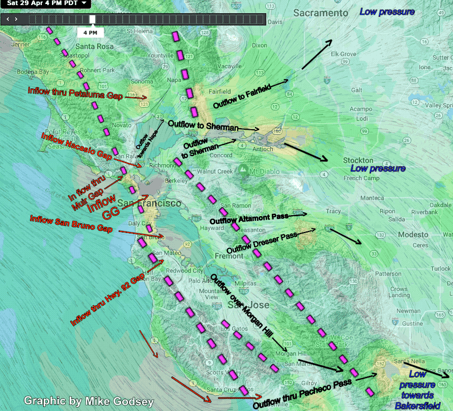
The Bay Area can have NW or W or SW or SSW ocean winds. Plus it has 2 barriers to block that wind. One barrier is the ridges of the coast range to the west of the Bay. Those are marked in this graphic by the pink dashed lines near the coast.
Then there is the barrier of the East Bay hills which is the inland pink lines.
So the inbound ocean winds that are sucked towards the Central Valley have to find a route to the valley first through the coast range then curve to find another route through East Bay hills.
Since the inbound ocean winds are always relatively cool and often foggy the marine air is denser and heavier than the air aloft. And often there is a strong inversion of warmer air pressing the marine layer towards the surface.
This means the inbound ocean wind usually can not climb the slopes of the coast range and has to weave through low-level gaps or valleys in the coast range and East Bay hills.
To make things difficult some of these gaps are at or near sea level. While others are just low spots several hundred feet above sea level. So the depth of the ocean marine layer is critical to which gaps the wind can flow through.
Even more important is the direction which a gap faces.
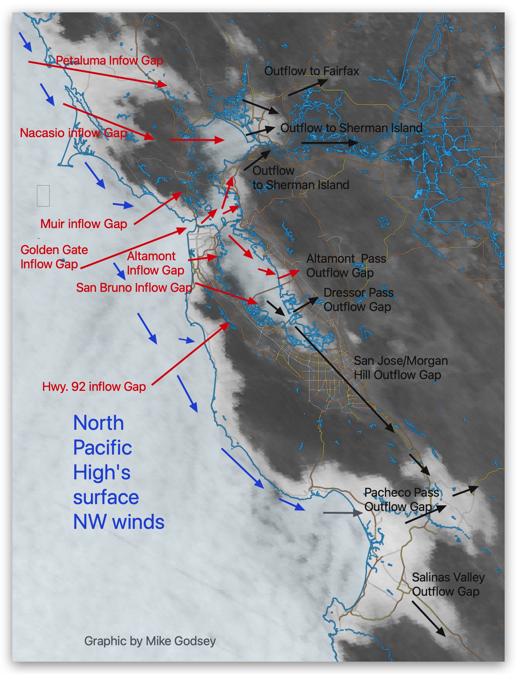
Some gaps like the Hwy. 92 Gap and the Muir Gap face SW so they mostly allow SW ocean winds to pour through them. Other gaps like that at the Golden Gate face West so NW or W or SW wind can funnel through the Golden Gate. Other gaps like the San Bruno Gap face NW so only NW to WNW wind can easily flow.
To make things easy to understand I call all the gaps that allow wind flow INTO the Bay “INFLOW GAPS” But once all this mass of moving air had entered the Bay it has to find a route through the East Bay hills. And none of the gaps in the East Bay hills are directly aligned with the “INFLOW GAPS” gaps in the coast range.
This means the wind coming through the “Inflow Gaps” has to CURVE towards one or more of the “OUTFLOW GAPS” through the East Bay hills. And these “OUTFLOW GAPS” face different directions and are also at different elevations. So the marine layer depth and the inbound wind direction favor
different gaps.
Most importantly which of these “OUTFLOW GAPS” is used depends upon where the pressure gradient is strongest in the 450-mile-long Central Valley.
If the pressure gradient is strongest towards Bakersfield then “OUTFLOW GAPS” that are aimed toward Bakersfield attract the winds. So wind coming in the NW facing San Bruno “INFLOW GAP” will mostly blow NW towards San Jose then over the Pacheco Pass “OUTFLOW GAPS” towards Bakersfield. But if the strongest gradient is towards Stockton those winds from the San Bruno Gap will turn more WNW and head towards the Altamont and Dresser “Outflow gaps”
If the max pressure gradient is towards Sacramento then a different set of “INFLOW and OUTFLOW GAPS” are the main flow pathways.
These graphics illustrate all this on one of those uncommon days when the pressure gradient the Central Valley is pretty evenly split between Sacramento, Stockton and towards Bakersfield. This means almost every “INFLOW GAP” and “OUTFLOW GAP” is being used and most sites see solid winds.