by Mike Godsey
The first 2 sentences of Kerry’s 7:30 AM San Francisco Bay Area forecast for today, August 31, was good news for kiters and windsurfers from 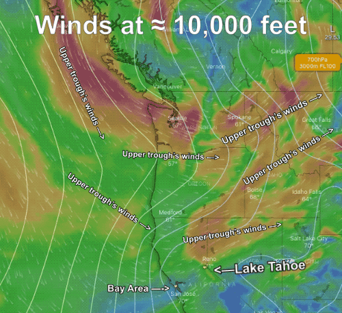 Larkspur to Sherman Island to Pt. Isabel to the Golden Gate. But to Tahoe firefighters and resident it described nightmare scenario.
“Morning Update: An upper-level trough is deepening southward out of the Pacific NW today and clips that area, helping to bring a little cooler temperatures inland. It is also deepening the marine layer so clouds are still filling in along the coast. The NW winds are picking up a little at the northern buoys. However, as this has happened we are seeing an eddy develop near the Bay so we are starting with S/SW flow …”
Upper troughs are southward extending loops in the upper-level winds that are often best visualized at the 500 MB. level which is about ≈ 18,000 feet aloft. Upper troughs bring cooler air from more northerly regions and their rising air allows the marine layer clouds to deepen and move more inland over the Bay Area. And this usually helps the winds at sites north of the Bay Bridge.
But Lake Tahoe in the Sierra Nevada is over 6000 feet elevation and it is surrounded by higher mountains and valleys. This means that the terrain around Tahoe is at an elevation high enough to feels some of the powerful wind of the upper trough.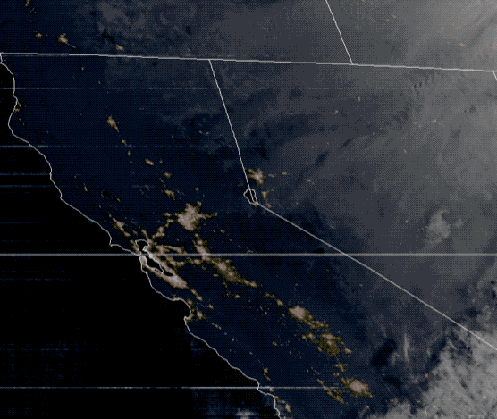
Looking at this first image notice the southward extending loop of upper-level wind at ≈ 10,000 feet. Notice that those winds are WSW over the Lake Tahoe region. Since Tahoe is surrounded by very mountainous terrain some of the upper trough’s wind will descend to the surface randomly fanning the flames of the almost 200,000 acre Caldor fire. The next animation shows the satellite imagery since dawn today. Notice how the smoke from the fires parallels the upper trough’s winds. These WSW winds from the upper trough are pushing the fire towards the city of South Lake Tahoe. Hence the evacuation of the city.
The only favorable aspects of the upper trough for Tahoe is the cooler air and increased humidity mentioned in Kerry’s forecast. Plus this a very fast-moving upper trough so it should be well east of California by tomorrow which will slow the fires progress towards the lake.