
 How often do you see forecasts like this in the Gorge? I mean we do sometimes do see summertime low to mid 30’s but what is with all the VERY GUSTY AND UNSETTLED….UNRELIABLE stuff.
Well the winds Benjamin is forecasting for this Saturday are very different from typical summer winds. As I pointed out in a recent blog the Pacific weather patterns are a mess and Saturday you will meet a small part of that mess up close and personal.
Let’s look at the first animation taken from the GFS model. In the first frame the winds in the Gorge and out in the near shore waters of the pacific look mild. But in subsequent frames you an see a potent extremely early season low pressure storm and its SURFACE winds. Notice the counter-clockwise spinning surface winds of the storm and how organized they are as they approaches the Oregon coast.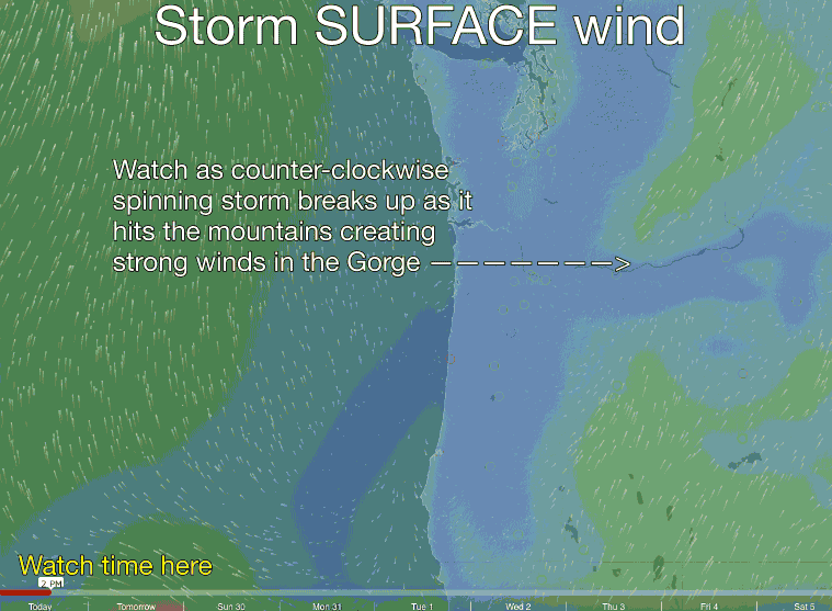
The air in these winds is “unstable air” which is geek talk meaning that the air at the surface is about the same density as the air aloft. Out at the ocean that does not impact the surface wind speed much. But notice how the wind pattern breaks up as the storm comes over the coast and hits first the coast range and then the Cascades.
As this wind hits topography it rises and since its density is about the same as the air aloft there is little to coax it back to the surface. So towards the coast people will notice blasts on the ridges but valleys will be more wind protected. So the overall flow of the storm wind becomes disorganized compared to the wind flow over the Pacific.
In the corridor this effect will be very noticeable and the winds will be unreliable with blasts and lulls. Once the storm wind passes the Cascades and encounters the less topographically complex land near the eastern Gorge it will settle out a bit and become stronger.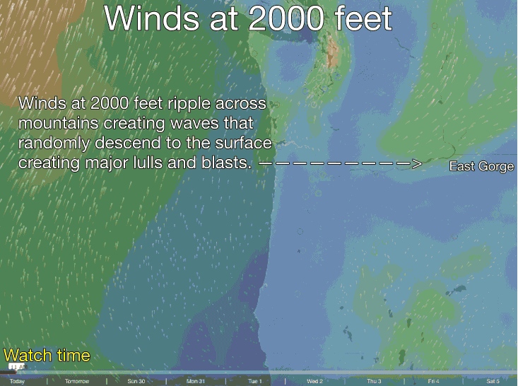
But there is a second factor behind the VERY GUSTY AND UNSETTLED forecast.
Take a look at the second animation. This image shows the winds at 2000 feet above sea level. Note how these winds are shown in a red to blue color indicating that they are stronger than the winds in the first animation.
As these winds, and similar winds at higher and lower levels hit the mountains they become turbulent and create up and down down stream oscillations much like
ocean waves but in this case the waves are composed of fast moving air.
Sometimes if the dew point is perfect you can actually see these waves as the water vapor in the rising part of a wave condenses forming a cloud while the clouds evaporates in the descending part of the wave. But tomorrow these waves will sometimes descend to near the surface. When that happens the powerful winds aloft transfer 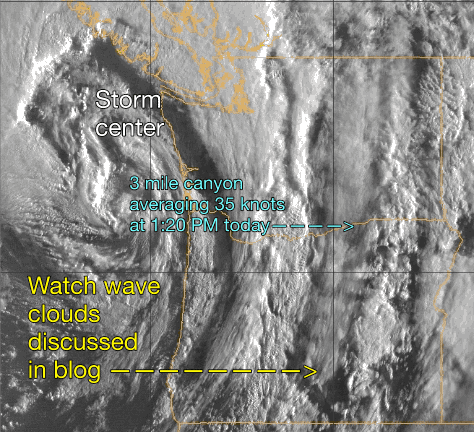 momentum to the surface wind and you experience a crazy gust.
Then a few seconds later the wave of storm wind lifts and you experience a major lull. If you are lucky and hit the water at the right place at the right time you might have an epic session. But at most sites the winds are going to be what Ben euphemistically calls UNSETTLED.
To increase your chances of finding wind that does not suck think of launch sites with barely any topography nearby. See you there!
Looking at the 2nd image can you figure out why there are such strong winds in the Willamette Valley as the storm hits the coast?
Update at 1:20PM Saturday. The new satellite video below shows  the storm
hitting the Gorge. As expected the strong winds are focused out east with 3 Mile Canyon averaging a steady 35 mph. Notice the wave clouds I mentioned in the blog.