If you live on the California or Oregon coast it seems like a regular day with dense fog at dawn. But above that fog and in the eyes of inlanders it is an atypical day with high thin clouds from the Sea of Cortez overhead from San Diego to the Columbia River Gorge.
So take a look at this satellite image from dawn today!

As you can see the upper high pressure at ≈18,000 feet that has brought a lingering heat wave to the west coast is also sweeping up moisture from the more tropical waters near Baja.
These clouds will weaken the pressure gradient to the Central Valley, Southern California Deserts and the Columbia Basin taking the edge off the wind at many launch sites in Southern California, San Francisco Bay Area and The Gorge.
Far more importantly, these clouds bring a risk of thunderstorms to the Pacific Northwest and California Cascades, Sierra Nevada, and California coast range for the next few days, especially this afternoon.

Given the winds, during this heat wave and the very dry vegetation this is low confidence, yet potentially high impact forecast for fires in California and the Pacific Northwest.
For the Pacific Northwest the Cut-Off upper low to the west at ≈18,000 feet adds to the moisture and instability increasing the risk.
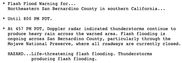
Here is the satellite imagery from predawn to 5PM. Notice how the Las Vegas region was hammered by thunderstorms. And much of Southern California Deserts had flash flood warnings. Meanwhile, most of the Gorge was missed but the Blue mountains of Oregon had strong thunderstorms.