
No, this is not the title of a romance novel but rather it explains the coming
weak wind weekend.
by Mike Godsey
So after today, Friday 14 the S. F. Bay Area and Southern California will see weak winds while the Gorge has a few days of glorious weather. (Should have said the Gorge was windless, clear and warm in the East and Corridor since high pressure inland means strong E. winds for Rooster.)
Often after the Bay Area and Southern California have had strong NW winds the forecasts will talk about a storm “crushing” the NPH against the coast and the winds building for one day only to die for several days. Usually these forecasts mention the North Pacific High “shrinking and departing our waters” While at the same time unfavorable NE winds develop in the AM.
To help you visualize all of this I have annotate this animation with isobars of high pressure in red/orange tones and the isobars of low pressure in the blue/purple colors. Note the time stamp at the bottom of the imagery. 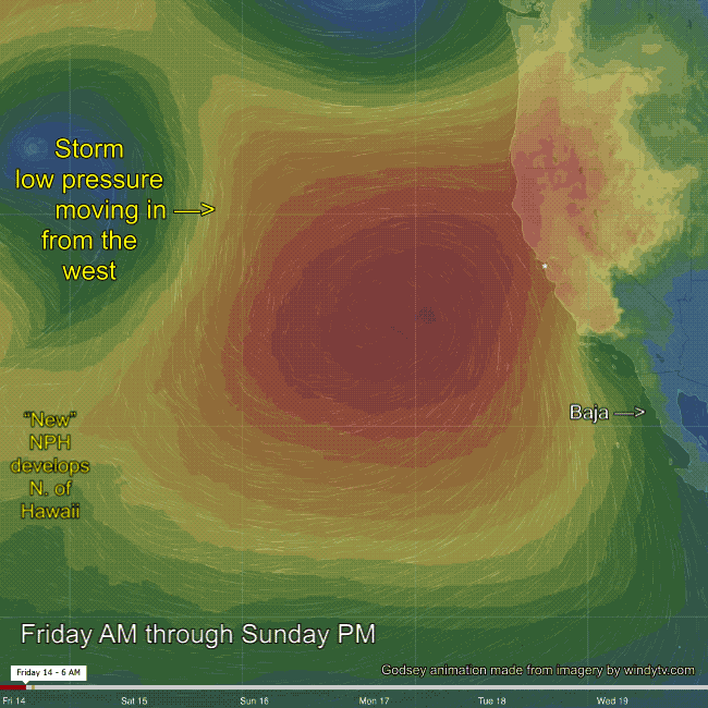
Starting Friday morning you can see the major players: A small North Pacific High delivering NW wind to the California coast. Then check out the storm system moving in from the west. Also check out the storm almost off the image near Vancouver Island. Together these lows encourage the NPH to push a high pressure ridge towards the Gorge.
In the subsequent frames notice how this high pressure ridge (in red) moves inland. This creates warmer clearer weather in the Gorge but it also creates mild NE flow in the California interior. This in turn makes it a bit more difficult for the ocean winds to reach into the Bay.
As the frames go by notice how the NPH becomes crushed against the California coast and the NW winds (indicated by the stream lines) turn more NNW and weaken. Finally the NPH is crushed into 2 parts. The northern part moves over the Gorge so there will great but windless weather there this weekend since the pressure gradient will be zilch. While the southern part of the NPH moves off Baja. This leaves California with only weak winds for the weekend.
Lastly notice the hint of a new North Pacific High forming towards Hawaii. At this time time it is not clear when this high pressure will move towards the California coast.