by Mike Godsey, mike AT kitesurf.com
Part ONE: Today, Sunday, February 17, 2019 the North Pacific High is pumping wind into the Sea of Cortez from the Pacific side of Baja. You can see this happening in Part 2 of this blog below. Since this Pacific wind is largely NW it arrives as side-offshore wind which is unfavorable for almost every site.
Fortunately, we have blue skies and as that heats the inland valleys like the Los Planes valley west of La Ventana a local pressure gradient is created that gradually curves the NW wind into North to even NNE wind. Since La Ventana has a very large valley in close proximity this curving effect works best there. While El Sargento and Los Barriles are more likely to have up and down and even shifty winds Inside. (This is an unusual wind pattern since usually strong winds down the Sea of Cortez are triggered by high pressure in the Great Basin NOT the North Pacific High.)
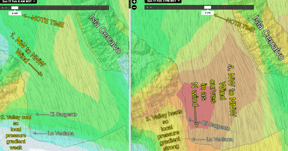
The first animation using model output captures this process pretty well for today. Note that the left side of the animation is for 8AM. The wind is relatively weak near La Ventana and El Sargento and you can see that the inbound wind has a NW to NNW component. The right image for 3 PM shows how the inland valley heating has 1. Curved the winds to a more N. direction and 2. local thermal winds have added to the wind.
Part TWO: Today, Saturday, February 16, 2019, the North Pacific High has NW wind roaring down the west coast from San Francisco, Calif. to Abreojos, Baja Sur. Mid morning the San Francisco Ocean Buoy has winds averaging 26 knots, while the Santa Barbara ocean buoys is averaging 22 knots and the sensor at Mag. Bay, Baja Sur is already at 21 knots.
But how does all this wind on the Pacific side help the sites on the Sea of Cortez side of Baja?
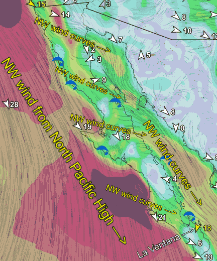
This animation from the ikitesurf.com LIVE WIND product shows the current sensor readings at 11 AM today superimposed with the hourly output of the 3 km HRRR model wind forecast. While models are far for perfect for very local winds they do a much better job on large scale winds especially over water.
So in this animation notice the powerful wind roaring down the west coast and the 28 knot average wind at the ocean buoys west of Baja and other wind reported on the west coast of Baja. But look at the area along the Baja and Arizona USA border. Notice that there is only faint to zero northerly wind coming from the USA Great Basin. Most winters it is this high pressure that makes our stronger winds. But NOT this week. Let’s check out how this happens.
Now look carefully at the modeled winds over Baja. Notice how that everywhere there is a valley or low spot in through the mountainous backbone of Baja the NW ocean wind curves over the land and pours into the Sea of Cortez as northerly wind. Unfortunately this means our inbound winds have a slightly side offshore angle at times. And, this wind has gone over relatively warm land which adds a gust factor. To get these winds to curve and fill into the beaches reliably we need and pressure gradient towards our iinland valleys. And the blue skies should deliver that as the sun heats the land!