
by Mike Godsey,
iwindsurf.com/ikitesurf.com
Weatheflow.com
So for days I have been saying the wind drought will begin to end Wednesday Feb. 6 and really end with a bang Thursday. This brief blog shows you the big picture behind this event. Remeber that wind is always produced by a pressure gradient. At the most local level heating in a nearby valley makes low pressure and a pressure gradient from the cooler air just offshore. But for big winds you need a larger scale pressure gradient.
In the first image you notice the huge dome of high pressure between the west coast and Hawaii. Note the isobars, lines of equal pressure, expending around the high pressure. So there is a strong pressure gradient from the center of the high pressure to the west coast of the USA. Next notice the low pressure in the Great Basin and the isobars extending from that low. Lastly notice that neither of these features are causing isobars over the Sea of Cortez hence the weak winds today.
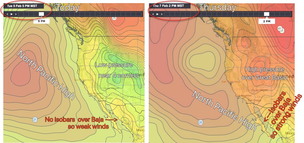
Now look at the image on the right for Thursday. Notice how high pressure has developed in the Great Basin and how the North Pacific High has shifted southward towards Baja. Together these events have stacked isobars over the Sea of Cortez. This will make strong northerly winds over the Sea of Cortez. The Los Barriles beaches gets these winds pretty directly but La Ventana and El Sargento need a bit of a local pressure gradient to get the wind to curve into the beaches reliable. Because this is not a classic El Norte event with high pressure just in the 4 corners the overall wind will have a bit WNW to it due to the North Pacific High. So we really need blue skies over the Los Planes valley for quailty wind.