This is just a quick visual on the just forming small eddy west of the Golden Gate. This eddy will greatly enlarge during the next 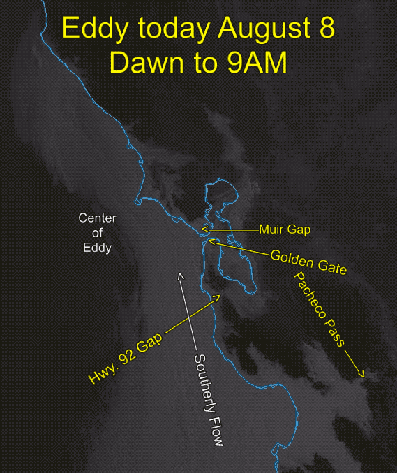 12 hours and bring southerly winds to much of the Central California coast.
It is all a matter of perspective…
All available data still supports this bipartisan forecast. Watch for updates since these elongated eddies can switch from SW to S. fast.
Forecast from Coast, Tomales, Rod & Gun, Coyote and 3rd. Ave.: The dreaded eddy and it’s evil SW coast wind continues as the North Pacific High misguidedly anchors a surface ridge inland from Redding to near Montana causing unfavorable NNW wind west of the ocean buoys. At the same time wind shear from weak NNE winds over the coast range and a surface lobe of high pressure over the N. coast together with an unfavorable counter-clockwise spinning air mass up to 6000 feet aloft acst to keep the eddies unfavorably southerly winds blowing all day. All this keeps the wind weak and unreliable
Forecast from North Tower to Pt. Isabel, Larkspur, Sherman Island and Candlestick: The beloved eddy and it’s great SW coast wind continues as the North Pacific High favors us by anchoring a surface ridge inland from Redding to near Montana causing favorable NNW wind west of the ocean buoys. At the same time, wind shear from weak NNE winds over the coast range and a surface lobe of high pressure over the N. coast together with a favorable counter-clockwise spinning air mass up to 6000 feet aloft acts to keep the eddies favorably southerly winds blowing all day. All this keeps the wind strong and reliable
Sherman and Benicia
Sherman – Dawn upper-teens, morning mid-teens then VERY LATE afternoon upper teens to weak low 20’s.
Benicia – SW winds upper-teens to 20.
Central Bay
Crissy – Upper -teens to low 20’s wind begin to build outside of Anita Rock. Fog may be an issue late.
Treasure Island – WSW upper-teens to low 20’s towards Point Blunt.
Ocean Beach – SW low teens.
Peninsula
3rd Ave – SW upper-teens eddy winds from the Hwy. 92 gap battle with WNW eddy winds that have curved through the San Bruno Gap. At this time it looks like the SW winds dominate at the launch. So SW weak winds near shore then WNW winds mid to upper-teens in the Channel
Coyote – SW low to mid-teens eddy winds from the Hwy. 92 gap battle with WNW eddy winds that have curved through the San Bruno Gap. At this time it looks like the SW winds often dominate at the launch. So SW weak winds near shore then WNW winds mid to upper-teens starting just outside.
Candlestick – W low to mid-teens
Palo Alto – N to NNW mid-teens.
Coast
Waddell – WNW southerly sub to low-teens. Natural Bridges WNW low mid-teens.
Stinson – Winds hinge on eddy dying. Probably weak WSW winds.
Bodega – Probably weak WSW winds.
Tomales – Probably weak WSW winds.
North and East Bay
Pt. Isabel – Upper-teens inside building to low 20’s near Brooks Island.
Berkeley – WSW mid to weak upper-teens.
Alameda – W. mid-teens.
Larkspur – SSW upper teens
Brickyards/Peacock Gap – SSW upper teens to low 20’s.