by Mike Godsey
Frequently I mention the winds at 1000 feet aloft (975 mb.) in my forecast which I am sure puzzles some of you. After all, your kite lines or mast extends mere feet into the atmosphere so why should you care about the winds 1000 feet aloft. Today it is very easy to visualize why these winds aloft matter.
Today, August 5, we are seeing very strong westerly winds on the San Francisco Bay Area ridgetops this morning as an upper trough at about 18,000 feet passes over us. Looking at the wind map of the Bay Area this morning at 7:35 notice how most of the Bay Area only has weak winds.
But also notice how the winds accelerate from Benicia to Sherman Island. This corridor from Benicia to Sherman Island is the only place in the Bay Area that is wide open to the west with steep hills to the north and south. This acts to funnel the winds just aloft over this corridor and some of this wind transfers momentum to the weaker surface winds increasing their strength and adding a gust factor. Looking at the wind graph notice the winds spikes and deep lulls which is typical when there are strong winds aloft.
Since we have deep marine layer clouds today this strong wind aloft creates the waves in the clouds you see over Sherman Island.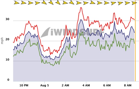
These are standing waves so while the rest of the marine layer clouds are moving inland these waves appear stationary as they constantly reform over that Sherman Island.
Notice how the clouds turn to the NE towards Sacramento due to the pressure gradient towards that direction. That pressure gradient would normally only produce upper teens to low 20’s wind today. But the winds a 1k aloft sort of turbocharge those pressure gradient winds.
Also, notice the holes developing in the marine layer clouds even over the ocean. This reflects the cooler air from the upper trough mixing out the marine layer clouds. That is why Año Nuevo and Crissy have a decent chance of clearing so both Waddell and Crissy may see wind today despite having clouds almost to the Sierra foothills at dawn.
Look carefully at the lower-left corner of the animation and you can see the NW winds moving the clouds. Those winds will move to the coast this afternoon.