Hi Gang,
Last night and dawn today, Sun, Aug 7, 2022, found Sherman Island ripping with W winds 25g32 range while the rest of the Bay Area was seeing sub-teen winds.
This brings up a bunch of questions:
- Why are the Sherman Island winds and nearby sites so much stronger than the rest of the Bay Area at dawn?
- Why were the Sherman winds gusting well over 30 at dawn?
- Why are the Sherman Island winds W rather than WSW or SW?
- Why does Sherman sometime blow all night long in the mid 20’s?
- Why do the Sherman winds often weaken some mid to late morning then rebuild in the afternoon?
This blog tries to answer some of those questions.
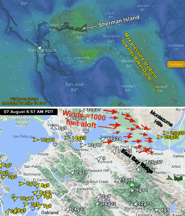
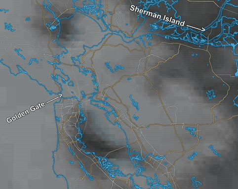
This first animation shows the surface winds in the Bay Area were very light at dawn. Notice how Benicia has mid-teens wind while Suisan Bay is upper-teens.
But by the time we get to Sherman Island we are seeing mid 20’s to low 30’s wind.
1. What causes this abrupt wind increase near Sherman?
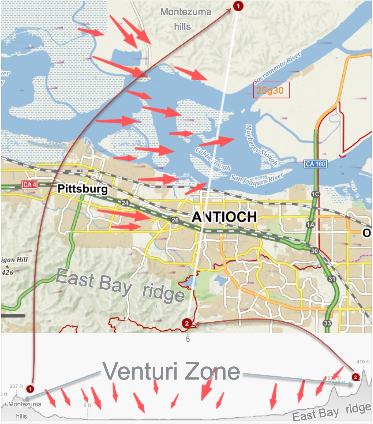
First, notice the low Montezuma Hills just north of Sherman Island. The notice the steeper hills south of Pittsburg. Since the inbound air in Suisan Bay is chilly dense air from San Francisco Bay it hugs the water. Plus it is vertically compressed by the inversion overhead.
So, as it hits the narrowing land masses created by these hills a venturi is formed funneling and accelerating the wind as it nears Sherman Island.
Take a look at the bottom of the second image. It show a the vertical cross section from the Montezuma Hills to the ridges south of Antioch. It does not look very impressive but give the heavy cool air headed towards Sherman Island the venturi works extremely well.
2. Why were the Sherman winds gusting well over 30?
Looking at the second part of the animation notice that the west winds at ≈1000 feet aloft (975MB level) are much stronger than the surface winds. Notice all the rough topography west of Sherman Island especially around the narrow Carquinez Straits near Benicia. This strong NW wind is above the inversion and warmer. So when it hits the terrain it becomes turbulent with up and down wind waves that transfer some momentum to the surface winds. Hence the gusts.
3. Why are the winds so West rather than our favorite WSW to SW. The answer is in the animation below. Look carefully at the ≈1000 feet aloft part of the animation. Notice how the winds passing over Sherman curve towards as they enter the Central Valley as the “feel” the pressure gradient towards Bakersfield. This favors W to WNW winds near Sherman Island. If the max pressure gradient was towards Sacramento and Redding we would be seeing SW winds at the Sherman Island Access.
4. Why did Sherman blow all night long?
This is a complex issue. Have you ever driven through the Central
Valley on a summer night and then into the Bay Area and across the Golden Gate? You probably noticed that the Central Valley was relatively warm all night but the deeper you went into the Bay Area the cooler it became. And crossing the Golden Gate you probably saw dense fog pouring into the Bay.
Since the foggy air is cool and dense it creates a low pressure area inside the Bay. Meanwhile, the warmer Central Valley air creates a low pressure zone. Sometimes it is the hottest towards Sacramento to Redding other times it is hottest in the Stockton to Bakersfield zone. As you know high pressure air flows towards low pressure creating wind. But chilly air is dense so it will take the lowest level pathway to the low pressure in the Central Valley. And, the only sealevel pathway from the Bay to the Central Valley goes right over Sherman Island. This creates strong winds that are further accelerate by the Montezuma Venturi.
5. Why will the Sherman winds weaken some mid to late morning?
This one is fairly easy. In the morning the summer fog is often over the East Bay hills. As the sun rises the Central Valley begins to heat and the fog retreats towards the ocean. Once the fog blanket is gone the land in the Bay Area heats warming the air and the high pressure that was helping drive the night and early morning winds weakens. As that part of the pressure gradient fades the Sherman Island winds weaken some mid morning. Then in the afternoon the Central Valley becomes even hotter and the pressure gradient to Sacramento, Stockton and towards Bakersfield goes up so the afternoon winds build.

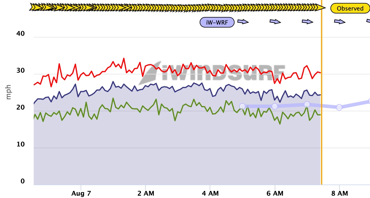
Today there was was only a minor mid day lull because these strong winds at ≈1000 feet aloft (975MB level) keep on blowing!
This cycle repeats itself daily in the summer as long as an eddy or upper trough is over our part of the Pacific to deepen the marine layer.