
 …As the North Pacific High takes an extended early spring vacation to the south.
by Mike Godsey
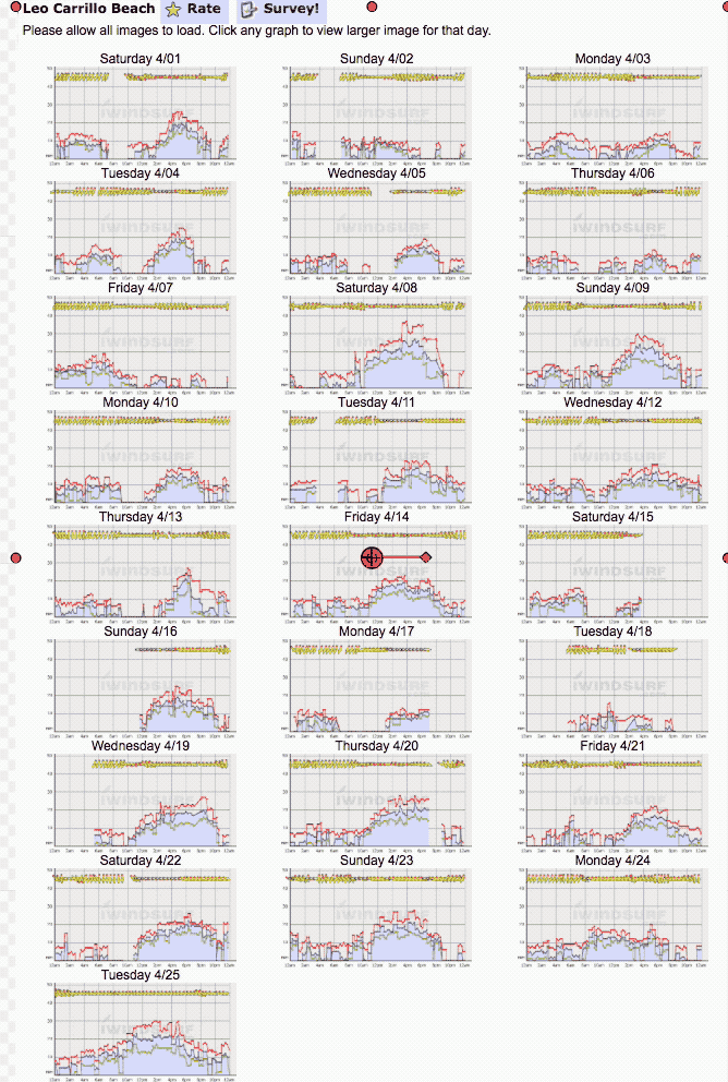
Compare the wind graphs for Waddell, normally one of the windiest spring sites in the Bay Area with Leo in Southern California. Notice have about the same number of windy days. Typically Waddell would have many more strong NW days and Leo, at least in recent years, would have fewer.
This spring the Southern California coast has the most consistent strong NW winds in quite a while. Meanwhile the San Francisco Bay Area’s coast and Peninsula, which usually see strong NW clearing winds in the spring, have had lots of limp days. While up near the Gorge the National Weather Service says Portland has experienced the most wet days in recorded history with 145 days of rain so far this winter and more rain coming. So what is happening?
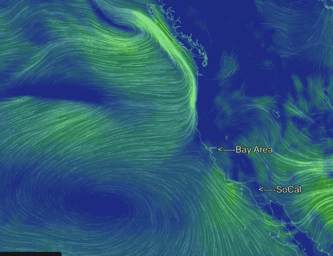
Looking at the first animation of the Surface Winds notice that the North Pacific High is centered almost due WSW of Southern California. Now NPH is always being bounced around the pacific but its average April location is further southward this year. And looking at the animation you can see this focuses the strongest NW wind in the Southern California area. Now notice the storm off the Pacific Northwest and the southerly winds north of the S. F. Bay Area. The southerly storm track that brought so much rain to California this winter continues this spring. And this in turn is often keeping the NPH in Southern California waters as well as keeping the Pacific Northwest wet.
So what is causing this more southerly locale for the NPH? Watch the animation as it jumps from the surface winds to the winds at the 500mb level ≈ 18,000 ft. Notice the upper ridges and upper troughs that act to steer storm systems and impact the position of the North Pacific High. This winter and spring these upper ridges and upper troughs extended more south and more north than the historical norm. This in turn promotes a more southerly storm track and slower changes in the weather. And this in turn has kept the NPH’s average location south of the Bay Area benefiting Southern California winds and keeping the Pacific Northwest wet.
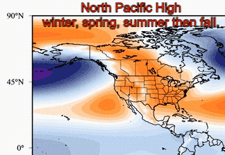 Year around there is almost always a North Pacific High located in the north pacific. But the North Pacific High waxes and wanes in size and its location shifts from south to north with the seasons. It is normally difficult to visualize this because the NPH is also bounced around and expands and shrinks with the passage of upper troughs and ridge way aloft. So to help you visualize this I have annotated an animation that shows the AVERAGE location of the North Pacific High month to month as averaged over 21 years. By averaging this data the day to day and week to week movements of the North Pacific High disappear and we can see the SEASONAL changes in the North Pacific High.
Looking at the animation most obvious movement of the North Pacific High with the seasons is its movement northward in the spring and it’s enlarging size. Also notice how the NPH shrinks in the fall and moves southward.
This year the North Pacific High has been slower than average in moving northward hence the Southern California, Bay Area and Pacific Northwest wind and weather pattern. Can you guess what this has meant for San Carlos, Baja Norte. In the next blog I will look at the migration of the North Pacific High in more detail. But remember that despite the North Pacific High’s southerly average location this spring it will invariable move into Bay Area waters as the days pass. Indeed I expect it to reach the Bay…. today April 27.