
The Gorge’s local sea breezes are an important but rarely visible part of the wind machine but they star in late summer.
by Mike Godsey
The Gorge wind machine is a complex beast driven by a bunch forces ranging from massive like the North Pacific High to mesoscale like the Columbia Basin to high altitude like passing short waves. But one of the critical components is the local sea breezes that rarely provide the baseline mid to upper teens winds to the Gorge. All the other components of the wind machine just add layer after layer of stronger winds. Indeed if the NPH and the Columbia Basin vanished the Gorge would still have weak local sea breezes. If visit La Ventana you are very used to local sea breezes fronts like you see in my title image above.
But normally in The Gorge you are barely aware of the local sea breezes except as the mild winds you barely notice in the morning while you are waiting for the “real” wind to arrive.
So let’s try to understand these local sea breezes. This time-lapse video shows faint local sea breeze arriving in the corridor this past Monday. This was a day with a limp pressure gradient to the Columbia Basin and with the North Pacific High to far to the west to have much impact on our wind and no upper shortwaves near us. So have one of those rare days when you can the wind of the local sea breezes is clearly visible.
Looking at the time lapse notice the marine layer clouds over and in the corridor and touching Mt. Defiance. The water in the eastern corridor is glassy calm and the Event Site sensor is showing faint East winds. Then over an hour or so the leading edge, or front, of the local sea breezes sweeps down the corridor from the west.
If you kayak or SUP from the Event Site towards the Hatch on a day like this you will feel weak easterly winds at your back as you glide over near glassy waters. Looking far to the west you see dark line towards Viento and with binoculars, you could see upper teens white caps. Now since these winds are only about 7 miles to the West and they are blowing at 18 knots they should be to you in about 20 minutes… right? Wrong!
The local sea breeze front is more complex than that. It took almost 1.5 hours for the front you see in the video to reach the Hatchery! Why? because the local sea breeze front is a complex 3D beast. In the graphic to the left you are seeing a very simplified 3D view both the wind circulation that creates these winds.
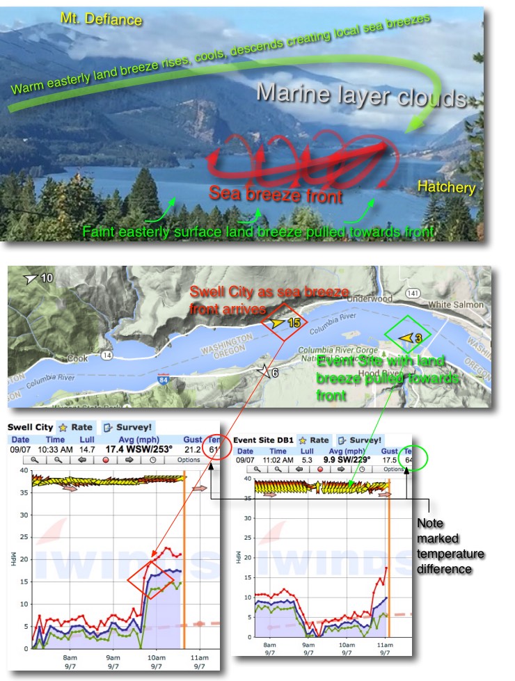 The local sea breeze starts as cool air associated with the marine layer clouds creates a local high-pressure zone in the far corridor. This thin layer of cool marine air is sucked eastward by the lower pressure of the sun warmed air just east of the corridor. As this marine air encounters the warmer air to the east it slides under the weak warm easterly wind.
As this warmer east air lifts, it encounters the cool air of the marine layer clouds and becomes denser and descends becoming part of the local sea breezes. This process generates a circular motion of the air at the FRONT of the local sea breeze. So the leading edge of the front not moving very fast horizontally except at the surface where it is 18 knots. Overall it is a rotating mass of air that slowly marches to the east at a much lower speed as you can see in the red arrows of the graphic.
So on your kayak or SUP you see the dark line of wind front approaching you at maybe 4-5 knots but once it sweeps over you will find yourself in 14 knots of unpleasant wind .
Remember that this type of local sea breezes is there almost every windy Gorge day but normally all the white caps from other parts of the wind machine make it almost impossible to see but you notice it on the water as the steadier wind that persists between the gusts and lulls genterated by other parts of the wind machine. And without the local sea breezes that is all you would have… gusts and lulls!