
While ikitesurf.com & iwindsurf.com say: “plus weak winds” Why?
 by Mike Godsey, mike AT iwindsurf.com
(Actually, the photo above is from the cam of the great folks the Alameda Boardsports facility)
So we just had a storm pass over Northern California yet there is no sign of the usual NW clearing winds from the North Pacific High.
Indeed looking at the animation to the right you can see that the models forecast almost no wind for the Bay Area, Northern California and the Central California coast. It is rare to see such faint winds in the Bay Area during the spring.
And the National Weather Service Synopsis says: Dry weather, along with a warming trend, is forecast for today and Tuesday. Rain chances return by late Wednesday and continue through the end of the week, but rainfall amounts are generally expected to be light.”
So what is going on?
One frequent criticism of our forecast discussions is our constant babbling about events far to the west or far aloft. This does not make sense to many customers who rightly only care about the surface winds right at their launch site. But the early part of this week is a good example of why we have to look far afield to make forecasts.
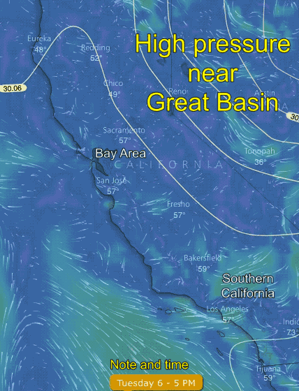
Looking at the first image again notice the isobars around the high pressure in the Great Basin. Such high pressure typically means warming, blue skies and light winds. Since this high pressure extends over the coast we will see light winds the first half of this week.
)Although the position of the high pressure will make for some very local upper teens just to our west near easterly facing gaps in the coast range. There are no launch sites that can take advantage of these winds)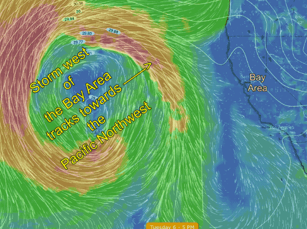
But the picture is more complex than that. Take a look at the second animation that shows the surface winds far to our west.
Despite the faint winds in the Bay you can see that there are actually strong storm winds just a few hundred miles to the west. Since this storm is due west of us and covers an area much larger than California you might expect that we are in for really strong storm winds and rain in a day or so.
Yet our extended forecast is for the storm to move very slowly and to only graze the Bay Area and to only bring weak southerly storm wind and not much rain. Why is this the case?
The third animation shows the wind patterns at ≈ 18,000 ft. First, notice how the surface storm is supported by an upper trough and its very strong winds far aloft.
Now notice the northward swing of the upper-level winds just over the Bay Area. This is called a blocking ridge and it will tend to block the eastward movement of the storm for a few days.
This upper ridge also helps keep our temperatures warm, sunny and promotes weak winds. Notice how the upper ridges wind just east of the storm are from the Southeast. At this time this time it looks like the winds of the upper ridge will steer the storm towards the Pacific Northwest.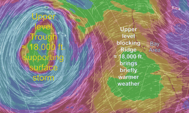
This means the Bay Area only get grazed by the surface storms winds and our rain is sparse.
Lastly, the big question is… what happened to the North Pacific High’s surface NW winds that never appeared after the last storm. Basically, the last storm system and the current one stalled to our west were too close together to allow the North Pacific High to develop near the coast. Far to the west a new North Pacific High is forming but I don’t expect it to arrive at our coast for at least a week. So this gives you an idea why we look so far aloft and so far to the west in doing out forecasts.