

The worse for 3rd & The best for Pt. Isabel.
by Mike Godsey, mikeATiwindsurf.com
The title may be a bit of an overstatement but it captures the flavor of the 2018 San Francisco Bay Area kite and windsurfing season at the 2 sites that suffered and benefitted the most.
Looking at the wind graphs to the right you can see that Pt. Isabel has had a great season with over 40 days where the sensor winds broke 20 knots. And typically the winds on the water are significantly stronger than at the sensor. True, there were some days when the great wind faded abruptly but still it has been a remarkable season.
Meanwhile 3rd. Ave., which for decades was one of the most reliable places in the Bay Area mostly had a disappointing year unless you were able to slog way outside and/or had great pointing abilities. True, there were occasional epic days but far fewer than in “normal” years.
Paradoxically, the wind patterns that made Pt. Isabel great this season was exactly the same patterns that often made 3rd. miserable inside.
In the simplest terms, Pt. Isabel likes overall SW flow while 3rd. likes NW flow. And Pt. Isabel likes a pressure gradient route from the ocean to the Central Valley from the Golden Gate to Sacramento. While 3rd. is favored by a pressure gradient route from the San Bruno Gap over Morgan Hill to Pacheco Pass area to the Central Valley. And this season SW flow and a pressure gradient route towards Sacramento was far more common than the pattern that favors 3rd.
So the next question is WHY so much SW flow?
Basically, eddy patterns, which used to be rare occurrences, have been becoming increasingly common in recent years and especially this year. Since the eddies are offshore and have a counter-clockwise spinning nature this means WSW to SW ocean winds near the coast. For 3rd this creates a convergence zone where NW-WNW flow coming from the San Bruno Gap battles with SW flow from the Hwy. 92 gap area. You can see this battle zone in my banner animation above. For details see this recent blog.
This battle between favorable NW-WNW and unfavorable SW-WSW flow as often fought close to the launch area at 3rd. making the winds inside weak or unreliable despite the useful winds in the channel.
So the next question is…. Why what causes the eddies?
The smaller eddies are the result of the surface ocean winds and/or the winds just aloft turning from NW to NNW to even NNE. How this makes an eddy is a topic for another blog but basically our typical NW ocean wind runs at a slight angle to the coast. But with NNW wind the velocity of the wind just offshore is much different than the velocity of the wind closer to shore. This wind shear gives rise to small eddies that we have named the “Golden Gate Eddy” since they are centered off the Golden Gate. These small eddies often die or fade midday as the NW ocean winds move closer to shore. If the eddy does not fade much SW flow along the coast jazzes up the Pt. Isabel winds while spoiling the 3rd. winds inside.
The larger eddies, actually surface lows, that were common this summer are partially caused by the same wind shear but were also supported by low-pressure areas over the ocean that extended from the surface to as high as 10,000 feet.
So the next question is…. Why so many eddies this season?
I have been watching the North Pacific High daily for over 40 years. One thing that has struck me the last several years is how huge 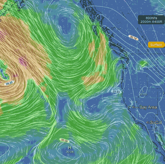 the North Pacific High has been this summer compared to past years. Often it stretched from the Bay Area to past Hawaii to near the tip of Baja. For most regions that depend upon the NPH for much of their wind, this was a good thing. But for the Bay Area it meant that the unusually large North Pacific High was often distorted by upper troughs passing to the north. And this distortion caused the isobars of the North Pacific High, which are usually roughly parallel to our coast and deliver NW wind, to bend inland so there were more at right angles to our coast. And this, in turn, made the ocean wind and the winds just aloft more NNW. And this, as described above, made both large and small eddies more likely.
So what does all this mean for the future?
I don’t know. But I can tell you what it probably means for the next several day. Looking at this animation you will notice that there is no trace of any huge North Pacific High. Instead there is a “northern” North Pacific High and a “southern” North Pacific High. This duality is happening as a Cut-Off Low up at ≈ 18,000 ft. west of California causes a surface low pressure you see west of the Bay Area. So for the next few days the North Pacific High’s surface NW winds are up in Canada and from Southern California to Baja. While we experience mild southerly winds.