Choose a Region
Northeast
Southeast & Gulf
Great Lakes
California & Baja
Northwest
Meteorologists
Tom Allen
Kerry Anderson
Claire Dupont
Chelsea Freas
Shea Gibson
William Gidley
Mike Godsey
Steve Gregg
David Hermann
Justin Hopkins
Oaklin Keefe
Mike Leiba
Kate Looney
Benjamin Miller
Mark Neveu
Hank Pomeranz
Matt Souders
Hans Vanbenschoten
Brad Wheelwright
Menu
Choose a Region
Northeast
Southeast & Gulf
Great Lakes
California & Baja
Northwest
Meteorologists
Tom Allen
Kerry Anderson
Claire Dupont
Chelsea Freas
Shea Gibson
William Gidley
Mike Godsey
Steve Gregg
David Hermann
Justin Hopkins
Oaklin Keefe
Mike Leiba
Kate Looney
Benjamin Miller
Mark Neveu
Hank Pomeranz
Matt Souders
Hans Vanbenschoten
Brad Wheelwright
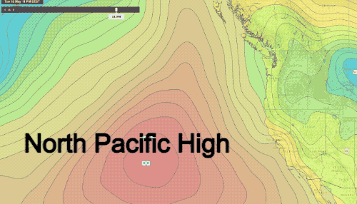
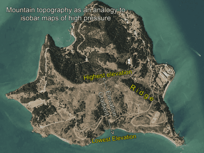
West Coast Wind Blog: Understanding isobar maps using a topographic map analogy.
Blog.WeatherFlow.com
>
California & Baja
>
West Coast Wind Blog: Understanding isobar maps using a topographic map analogy.
By Benjamin Miller
May 11, 2017
in
California & Baja
By Benjamin Miller
More from Benjamin Miller