 Hurricane Sergio boomerang!
by Mike Godsey, mike@iwindsurf.com
So take a look at this first image. It shows the tracks of all the hurricanes in the eastern Pacific in the period 1980-2005.
It is clear that the vast majority of such hurricanes originate off Central America then curve south of the tip of Baja then zoom out into the Pacific where they die without reaching Hawaiian waters.
So, with those tracks in mind, you would have might be impressed by this 2nd image of 115-knot hurricane Sergio with is eye looking spaceward.
But since it is firmly on the track far into the Pacific you would never think that Sergio could somehow bring downpours and possibly local flooding in Southern California and Arizona and especially the Punta San Carlos, Baja Norte wave sailing mecca.
But in the third image take a look at all the different models that have hurricane Sergio making an abrupt right turn and boomeranging back towards Baja.
The models differ a bit in their projected trajectory and a few model runs even have the hurricane following the traditional track eastward. But at this time it looks like Sergio tracks towards Phoenix where it fades and returns into a low-pressure system with light winds but torrential rains.
So what is behind this weird boomerang?
Occasionally in our forecasts, we will mention something like: “upper-level winds at ≈ 18,000 ft. will steer the North Pacific High closer to the coast so the NW winds ramp up” And you probably wonder: “How in hell can winds 3 miles above my launch site impact the wind in my kite or sail?”
The answer is that surface large-scale high-pressure areas like the North Pacific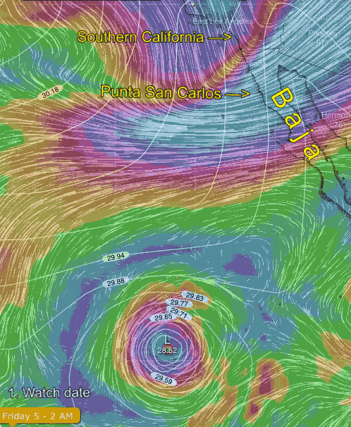 High and winter storm low-pressure systems are both steered by the upper troughs and upper ridges at ≈ 18,000 ft. and above to the jet stream.
Usually, eastern Pacific hurricanes are generally too far south to be fully steered by upper-level winds. However, it looks like this week a very pronounced upper trough at ≈ 18,000 ft. dives southward towards Sergio and steers it in a radically different direction.
In this last image, you can see how the Euro model projects this happening.
This is a composite image. The white lines so the surface isobars that help define Sergio. All the colored areas show the winds at the 500 MB level that act to steer weather systems in general and, in this instance, Sergio.
You might wonder why Sergio’s movement is so abrupt and so long while the typical movement of the NPH is slower and over shorter distances. Basically this is because a hurricane is composed of wind spiraling into the center then ascending so upper-level events can rapidly change its strength and direction. While the North Pacific High is descending air spiraling outwards so it is not so easily impacted.