
by Mike Godsey, mikeATiwindsurf.com
With a bit of luck and a Cut-Off Low that behaves according to the models we see a 3-5 day El Norte blow for La Ventana and Los Barriles, Baja Sur.
This graphic for Saturday Nov. 30, 2019, shows the setup.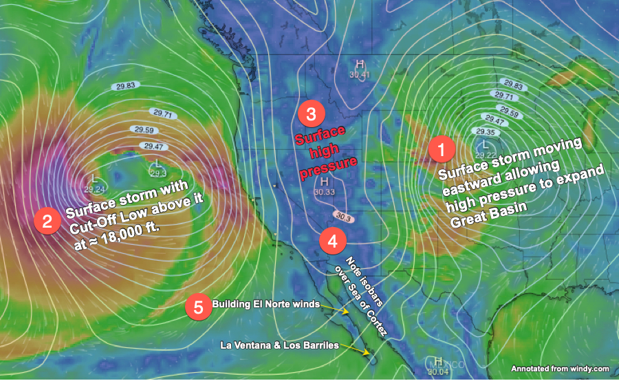
1. First, notice the huge storm over the mid-USA. This low-pressure system, that brought crazy winds, rain and snow to much of the west coast a few days ago is now tracking eastward.
2. Now note the second large storm out in the Pacific just off the west coast of the USA. Normally this storm would bring a day or two of stormy weather to the west coast and then move into the Great Basin displacing the El Norte wind creating high pressure located there. But far above this surface storm at ≈ 18,000 ft. is a near Cut-Off Low that is mostly disconnected from the upper winds that steer weather systems from west to east. This means this surface storm is likely to just loiter off the west coast for a few days.
3. Check out the small high pressure area in the Great Basin. This high pressure should cause El Norte winds today that augment the La Ventana local sea breezes today.
4. Notice the isobars extending from that high pressure. The closer those isobars are to each other the stronger the pressure gradient making for stronger winds.
4. This is creating the El Norte winds indicated in green in the Sea of Cortez. If that Cut-Off Low above storm#1 holds station while storm #2 departs eastward then the high pressure#3 can stay over the Great Basin and we see days of El Norte winds.