
NNW ocean winds and NE inland winds battle near Pismo Beach making forecasting tricky.
 I know it is frustrating when the wind forecast babbles on with lots of maybes and issues etc.
Today’s wind forecast for Pismo Beach is a classic.
The forecast talks about very strong ocean wind but it ends up telling you to just watch the sensors. Worse ends asking you to watch sensors miles to the east where you could never kite.
Lets dissect the issue behind all this waffling.
In the fall the North Pacific High moves southward first depriving the Gorge of part of its wind machine and then the S. F. Bay Area. But it often lingers near Southern California for a couple of weeks in the fall so the ocean winds may build there.
Unfortunately, this year the North Pacific High as often pushed an extension or ridge into Northern California. This results in the normal NW ocean wind turning a less favorable NNW and for the winds in the interior of Southern California turning NE in the AM.
Let’s look at this animation to see how this pattern gives our forecasters an excuse for a Pismo forecast full of maybes!
First notice that the animation shows the winds at 6AM then at 5PM.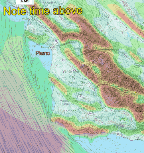
At 6AM notice the weak NNW morning ocean winds and the NE winds inland. The NE winds is warm winds so it is mostly felt on the ridges and a few canyons and often does not make it to the surface at the surface at Pismo.
AT 5 PM, or actually even earlier, the pressure gradient towards Cuyama Valley & Los Olives and the northern Southern California bight has become strong. Notice how this has caused the North Pacific High’s surface NNW winds to curve near the Pismo coastline as NW wind. Ideally this wind would curve in as more WNW but that is unlikely today.
Next note how the NE winds are not modeled to fade today. So we have a battle line between the cool surface NW winds, which are building, trying to get the beach while the warm, but fading, NE winds on the ridges and just aloft try to blow over Pismo. Forecasting exactly where this battle line will be is impossible since it depends on the relative strength of each of these winds and their change in strength over the afternoon. So all I can do is to tell you to watch the inland sensors. If you see the Tepusquet and other nearby inland sensors showing fading NE winds early then there is a good chance the NW winds will reach the beach near Pismo.