
 The North Pacific High’s surface NW winds are siphoned off towards the Pacific Northwest
by Mike Godsey
So it is beach meteorology folklore that after a spring storm that the skies clear and the S. F. Bay Area has strong to wild NW clearing winds? So why did Kerry and I forecast weak winds today after the weekend’s storm?
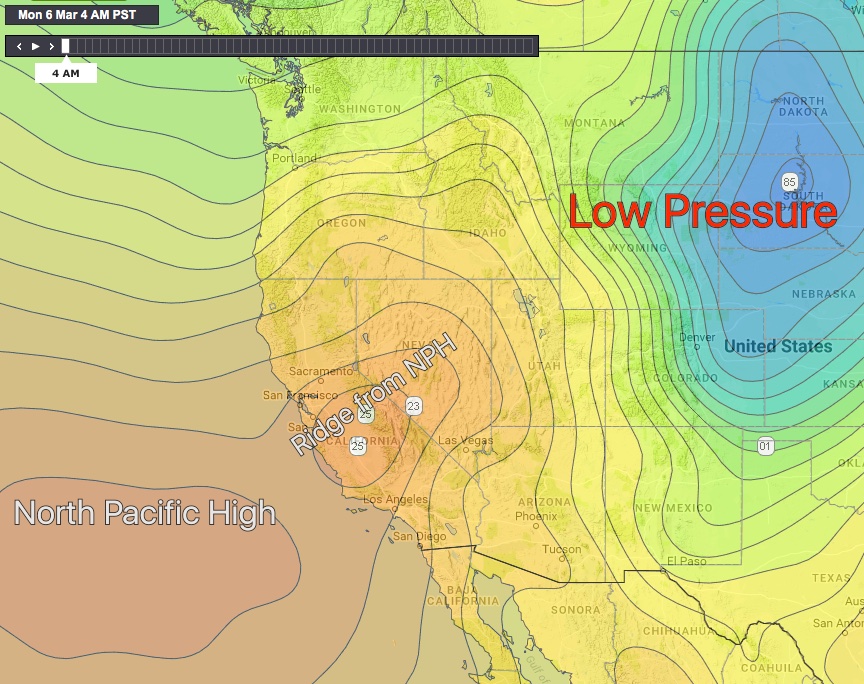
First take a look at the isobar map for this morning. Isobars are lines that represent areas that have the same atmospheric pressure.
Note the North Pacific High in the lower left corner. This is a dome of high pressure air from which wind spirals outward in a clockwise fashion. Notice the isobars that extend outward from the center of high pressure. The pressure is the strongest at the center of the NPH. Why? Well you can visualize the North Pacific High as a mountain or dome of air and since the atmosphere is thicker in this dome there is higher pressure.![]()
Usually after the passage of a storm there is lower pressure air in the California Central Valley and/or in the Great Basin. This creates a pressure gradient between the North Pacific High and that low pressure. Hence NW clearing wind.
But looking at the map again notice that the North Pacific High dome of high pressure has an extension extending into California over the Bay Area, the Central Valley and Great Basin. Just like mountains have steep ridges extending from their crest the NPH sometimes has ridges of high pressure extending from its center. Since this NPH ridge is an area of high pressure it spoils the pressure gradient from the pressure gradient to the Central Valley and Great Basin. So we lose the NW clearing wind!
But where does all that post storm NW wind disappear to? Well today there is a huge low pressure from the recent storm in the Columbia River Basin and points east. You can see it in the upper right corner of the map. So now we have a pressure gradient from the North Pacific High towards this low pressure.
As you can see in the next animated image (annotated from earth.nullschool.net) most of our clearing winds is being diverted towards the far Columbia Basin and the Rockies.
So can you see why we are only forecasting weak SW winds for most sites?