Part one of this blog below is about the smaller eddies mostly in the Bodega to Golden Gate area that have been so common during the 2019 summer season. These eddies often totally or partially die in the afternoon making for extremely difficult forecasts since the southerly eddy wind may die allowing NW wind to curve into Bay.
Part two of the blog, coming soon, covers the huge elongated eddies that have also been common this season. These eddies may span the waters from Pt. Arena to past Big Sur and usually endure all day and throw southerly wind at the Bay Area all day. These huge eddies are easy to forecast.
At this point, if you are a coast or 3rd. Ave. kiter or windsurfer, you are fed up with all these eddies and all the forecast talk about eddy. In feedback, customers have even accused us of just pasting in a boilerplate text about eddies rather than doing original forecasts. And I can understand that thought since time and time again almost exactly the same eddy producing conditions have developed and it is hard to come up with new phrases to describe essentially the same pattern.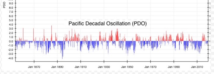
Does this text sound familiar: “The North Pacific High pushes a lobe of high pressure into far Northern California so our ocean wind west of the Farallon Islands turns from NW to NNW. At the same time, low pressure bulges over the coast west of Chico. So we have an eddy in the Bodega to Daly City zone. Meanwhile aloft strong NNW winds aloft create wind shear enhancing the eddy. In the afternoon the eddy probably fades but still enhances north tower to Point Blunt to Pt. Isabel winds while residual SW flow in the Hwy. 92 gap make the winds unreliable at the 3rd. Ave launch site.” If you are a 3rd. Ave kiter those words bring dread while Pt. Isabel windsurfers rejoice.
So where are all these eddy conditions come from and where are our normal NW winds from the North Pacific High?
Short answer: Unusually warm north Pacific encourages North Pacific High to expand northward and southward while El Nino southerly storm track causes NPH to kink inland over far Northern California so our ocean winds turn from NW to NNW while low pressure moves over the north coast and the combo results in eddies.
A Longer but still very simplified answer:
1. El Nino has brought warmer waters to the north Pacific and this encouraged the North Pacific High to move much further northward than normal.
2. This year we are in an exceptionally warm phase of the PDO or Pacific Decadal Oscillation this also encouraged the North Pacific High to move way northward.
3. Arctic warming has continued and Alaska lost all of its sea ice in August. This also encouraged an expansion of the North Pacific High and at times it reached into the Bering Sea and even over Alaska and well into the Arctic. Normally the bulk of the North Pacific High is west of the Gorge by mid-summer.
4. The combo of 1+2+3 above means we often had an NPH wind a weird elongated shape stretching from Alaska into Baja waters.
5. This winter saw an El Nino pattern with the storms taking an unusually southerly track hence the heavy snowfall and even rain in La Ventana, Baja.
6. Then as we moved into summer the storms became less frequent and smaller but they still tracked more southerly than usual bringing unstable convective air over the Pacific Northwest making for less reliable and more up and down Gorge winds. This is happening even though in the tropics the El Nino is fading to neutral. In the second
image, you can see 2 low-pressure systems and their southerly track and the fragmented nature of the North Pacific High and its N. and S. expansion.
7. As the storms tracked across the Pacific from West to East they often encountered the greatly distorted N. to S. North Pacific High. Often the North Pacific High was even split into 2 or 3 parts by these storms leaving Northern California with a North Pacific High that was off our coast rather than the Gorge coast.
Compare the second image of the fragmented North Pacific High this July with the third image showing the average shape of the North Pacific High in July over the period from 1967 to 2010.
So let’s look at how we make the shift from a strong NW pattern like we saw Wednesday, August 21 to the beginning of an eddy pattern today 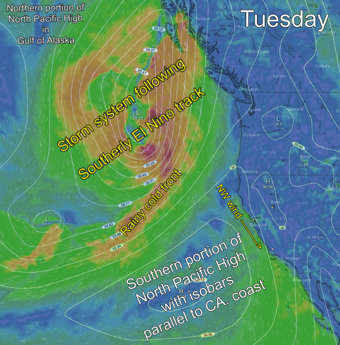 Thursday, August 22. Then in Part 2, we will see how Thursday’s tiny, quickly destroyed eddy turns into a massive elongated eddy Friday, August 23.
NOTE: There are 10 seconds between frames in this animation.
In the first frame, showing Tuesday to late Wednesday, notice how in the first image the North Pacific High’s isobars (in white) are roughly parallel to the coast so strong NW surface winds are along the Bay Area coast.
Then in the next image, for Thursday, the isobars of the North Pacific High begin to move inland into far Northern California while at the same time low pressure bulges over the coast north of the Bay Area. This causes a tiny eddy to develop in the Stinson Beach area just north of the Golden Gate.
This tiny eddy is destroyed later Thursday morning by the strong NW ocean wind.
The next image, for Thursday, shows the very strong winds up at ≈ 18,000 ft. that cause the North Pacific High’s isobars to kink inland over far Northern California setting the stage for an eddy.
The final image shows the very strong winds at NNW to NNE winds at 2000 feet that reinforce the eddy b and end up forming a counter-clockwise spinning mass that causes the eddy to endure all day and to exp
How about the future and eddies?
This El Nino is already fading so that causal factor is gone for a while. Likewise, the PDO should move to a cool phase in a few years. But Artic warming is going to be with us for a long time. So we are unlikely to see as many eddies next year the future is going to see more eddies than we did even 5 years ago. So eddies are going to be a factor in the future.