by Mike Godsey, mikeATiwindsurf.com
Take at this Baja California forecast valid for Thu, Dec 12 2019
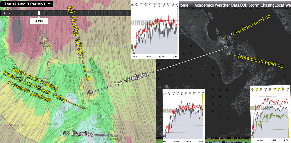
Once again our ikitesurf.com sensor network and the ASCAT satellite imagery show continued El Norte winds coming down the Sea of Cortez. Unlike a typical El Norte these winds are from 3 sources: 1. NNE winds from the North Pacific High, 2. ENE winds at 1000 feet aloft that may sometimes transfer energy to the surface as gusts and shifts. 3. Weak high pressure in the Great Basin. Plus, of course, our mild local sea breezes. All this suggests gusty shifty winds which may be aggravated by the low-level clouds curving into the El Sargento mountains. Gusty upper-teens to around for Baja’s East Cape with fewer clouds than yesterday.
Why was the forecast for such GUSTY winds?
First looking at the model streamlines for today on the left side of this animation. It looks a great day. Note the very strong El Norte winds north of La Pacific and a bit weaker for Los Barriles to the south and weaker yet for La Ventana. But still, who is going to complain about upper-teens to weak low 20’s winds.
But now look at the 2 wind graphs from our sensors in the area. Notice how jagged the graphs are indicating gusty winds near the shore. Once you got a bit outside the wind quality went way up.
Today the cause of that gustiness is largely the cloud build-up you see in the mountains N. of El Sargento and in the Los Planes Valley. The day was not anywhere near as bad as recent days but it was still not the rock study winds La Ventana used to be famous for years ago.