
Yep! NW clearing winds in Oct!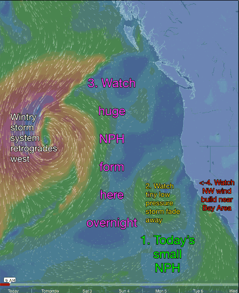
by Mike Godsey
For many days a weak surface low pressure has been blocking the North Pacific High’s surface NW winds from reaching the Bay Area. Finally yesterday the upper trough at ≈ 18,000 ft. brought some scattered showers to the Bay Area. Nothing unusual about all of this. But what is unusual is the NW clearing winds we see tomorrow. Typically this time of year the North Pacific High is small and well offshore. But overnight the tiny NPH you see at the start of this animation expands hugely so it spans the pacific waters from Baja to the Gulf of Alaska.
- Notice the small North Pacific High off Southern California today. This is a good position to give Southern California some upper teens wind today but it does nothing for the wind starved Bay Area.
- At the start of the animation find the counter-clockwise spinning winds of the tiny low pressure that has been keeping the Bay Area winds weak. Watch carefully since this feature gets blasted apart fast in the next 12 hours.
- Next watch as a huge but elongated North Pacific High forms. You can recognize it by the clockwise winds that spiral out of the high pressure.
- Now watch as the North Pacific High’s surface NW winds build near the Northern California coast.
 But there are some issues with NW clearing winds this time of year. The Central Valley and the Great Basin are beginning to cool. This means the pressure gradients will be mild. This is a similar scenario as we see in early spring when there is strong NW wind at the ocean buoys but coaxing the wind through the gaps in the Bay Area coast range is problematic since there is a weak pressure gradient.
You can see this issue in the first half of the 2nd animation.
The light orange color you see about 10-20 miles west of the Bay Area is the North Pacific High’s surface NW winds. Notice how they fade away near the coast. By themselves these surface winds would only bring upper teens wind to sites near at or near the coast.
The second half of the animation shows the winds at about 1000 feet. Notice that they are much stronger than the surface winds. My forecast for GUSTY upper teens to weak low 20’s tomorrow hinges on these winds at 1000 feet hitting the coast range and creating NW moving turbulence that stirs up GUSTS at the surface. Time will tell if I am right.