Lingering storm system keeps NPH from Bay Area.
by Mike Godsey, mike@iwindsurf.com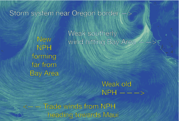
Well the scattered showers have subsided and the skies are mostly blue so where are the typical strong NW clearing winds from the North Pacific High? And why are the ocean winds more WSW to weak NW the next few days rather than the normal strong NW seen after a storm passage?
This animation tells the story. First notice the clockwise spinning storm system just west of the Oregon border. Then notice the strong storm winds hitting far Northern California. Since the Bay Area is on the fringe of these winds we see only modest southerly storm winds today. However with more powerful winds aloft there may be some strong pulses at a few sites.
Now looking towards the lower right corner notice the “old” NPH. The storm system pushed this high pressure southward the last few days and its NW winds are now focused in the outer waters off Southern California. So when do we get strong NW winds again? Look several thousand miles to the west of the Bay Area and you will see the clockwise spiraling winds of a new North Pacific High forming north of Hawaii. Notice how the winds on its southern boundary combine with the winds of the old NPH to create easterly trade winds for Hawaii.
Unfortunately that storm system you see off the Oregon border breaks up and reforms over the next few days so the new NPH will take a few more days to reach the California coast.