Too much of a good thing: when NW 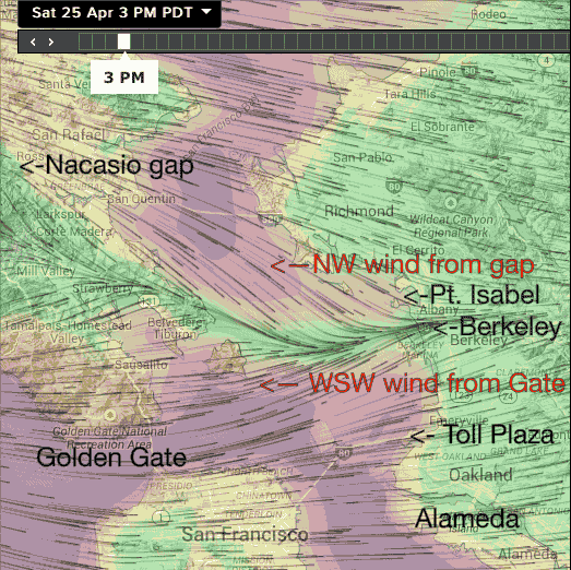 and WSW winds fight.
by Mike Godsey, mike@iwindsurf.com
Yesterday, April 25, I forecast strong winds at almost every site. However the text for the East Bay had some caveats:
Pt. Isabel: “WSW winds ramp up the turn NW and die.”
Berkeley: “WSW winds build to upper teens but may fade fast”
Toll Plaza: “Upper teens but on the edge of weak wind zone”
Alameda: “Upper teens”
And for most part the Bay Area actually had strong winds at most sites but for Pt. Isabel and Berkeley the caveats came true.
Let’s do an analysis of why Pt. Isabel and Berkeley suffered while the Toll Plaza, Alameda and rest of the bay saw 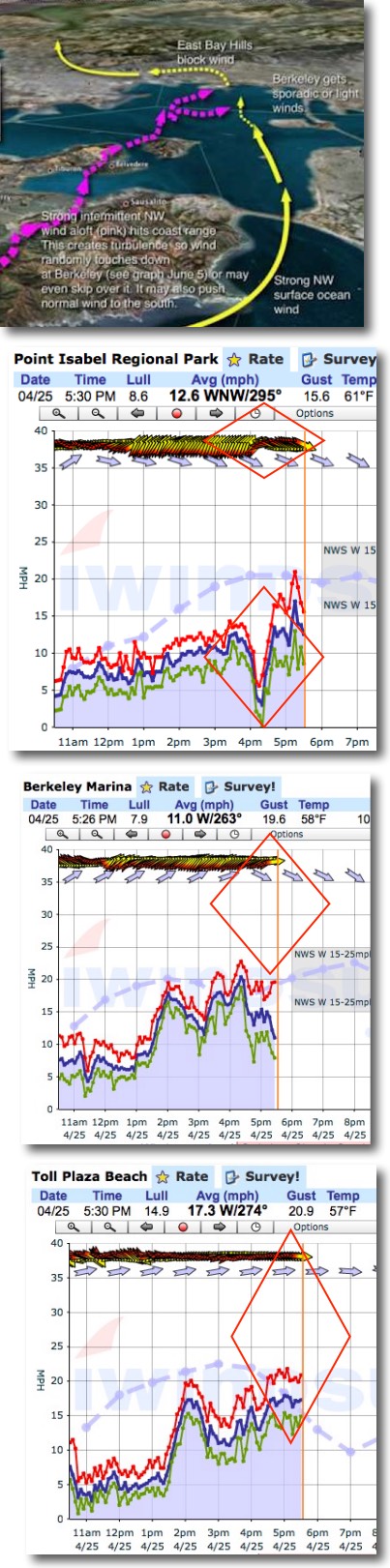 good wind.
Looking at the animation notice the wind coming through the Golden Gate and then curving from west to WSW winds as it approaches Berkeley and Pt. Isabel. This curve is typical due to the SFO-SAC pressure gradient and the face that the only sea level avenue for wind is to head towards Sherman Island.
The reddish color indicates wind in the low 20’s range. Note how this red zone extends from the Golden Gate past Treasure Island but then fades before reaching Berkeley and Pt. Isabel while it does reach the Toll Plaza and Alameda.
Notice the green weak wind strip from about Angle Island all the way to the race track zone.
Now notice the NW wind coming through the vague circuitous Nacasio & Fairfax Gap. This gap extends from the coast, past Tomales Bay and branches to deliver wind to Rod & Gun and Bullhead flats.
If there are strong NW winds aloft as well as strong NW surface wind the combo reaches the area of the Richmond San Rafael Bridge.
As this NW wind ramps up it begins to collide with the WSW winds heading towards Pt. Isabel and Berkeley. You can see this clearly in the animation at 3PM yesterday.
The next graphics allow you to visualize this easier. Notice that the NW wind pushes the WSW winds towards the Toll Plaza and Alameda.
The next 3 wind graphs from yesterday shows how this impacted the East Bay sites.
Looking at the Pt. Isabel graph notice how the winds was WSW and building then about 4PM you can see the winds abruptly switch from WSW to NW and die. Then towards 5PM the NW wind continued to build and at those launch sites closer to Pt. Richmond it may have been useful.
The next graphic shows the impact of the NW flow on Berkeley. The picture here is more complex since Berkeley was on the edge of the NW flow. Notice how the WSW winds pump up and down.. This occurs as the NW wind just aloft randomly pushes the WSW winds away from Berkeley. Finally towards 5PM the wind goes from WSW to W and dies.
Meanwhile the Toll Plaza is beyond the reach of the NW flow so the winds do not fade. So on days when you see this caveat in the forecast consider heading to the Toll Plaza or even Alameda.
“A tongue of NW surface winds comes through the Nicasio gap then through Pt. San Quentin and Pt. Richmond will try to block the W to WSW from the Golden Gate. Mid afternoon this will cause a fade at Pt. Isabel then the wind turns more NW. Berkeley will be up and down and may die”
This NW effect is usually easy for me to forecast but unfortunately I can not be 100% certain that it will be strong enough to spoil the winds. And if the NW wind does not reach past Pt. Richmond there can be fine winds at both Pt. Isabel and Berkeley. You can fine tune my forecast by looking at the Tomales sensor reading as well as the Rod & Gun sensor reading. If they show strong winds then be ready for an East Bay fade.