Video: Transfer of momentum to the surface.
by Mike Godsey, mike@iwindsurf.com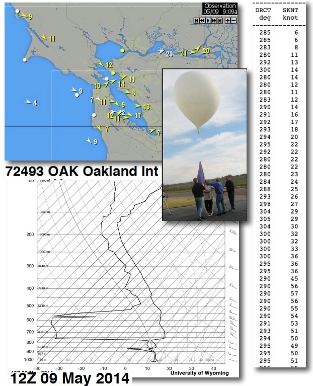
Have you noticed that I often mention the hilltop winds in the forecast. You may have wondered why they are important since you sail and kite at the surface. Actually most of the summer the wind aloft are NOT very important in the surface wind strength but they do impact the distribution of the fog and the direction of the surface wind.
But in the spring when there are not heavy marine layer clouds the wind aloft can impact the surface wind strength. As the wind aloft hits the coast range is becomes turbulent developing waves and even rotors. At times these strong waves in the air coming in from the NW come close enough to transfer momentum to the surface winds. So those surface winds become stronger than the pressure gradient alone would create.
You can especially notice this in the AM when the pressure gradient is still weak yet sensors about the bay pick up stronger winds than you would normally expect at 9AM. Later in the day when the surface wind is stronger these waves will create strong gusts as they pass overhead. And on some days they even make the wind UP AND DOWN as waves arrive then depart.
Today, May 9, is a good example. Looking at the first image note that the channel marker for 3rd Ave. is already 17 knots. Most of that 17 knots is coming from the winds aloft. These AM winds will probably fade later this morning but will come back even stronger this afternoon as the North Pacific High’s surface NW winds ramp up. Then we will see a combo of the ocean wind and some gusts transferring from aloft.
One very useful tool in looking for this transfer of momentum is the Oakland weather balloon that is launched every early morning and early evening. As the balloon ascends its weather instruments pick up the winds strength and direction as well as a host of other variables. Looking at the outputs you see in the imagery I can look at the speed and direction of the winds aloft (note that it is blowing NW over 5o knots but that is at ≈ 18,000 ft. . But most important bit of data stability of the near surface air. If the air is very stable, like it is when we have a well developed marine layer, then there will be little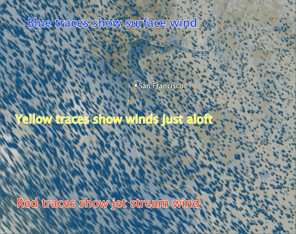 transfer of momentum. But if the air is more unstable then I will add a few knots to the forecast and also add a gust factor.
Let’s take a ride on the Oakland weather ballon from the surface to the jet stream in this video. Watch the wind from the surface today all the way to the jet stream. Notice the blue surface winds are relatively weak but as we ascend the wind becomes much stronger. Most of this wind does not impact the surface NW wind but the wind you see in the greenish traces can imnnpact the surface wind if there is topography to the NW and the air is unstable like today. This sort of tool is not very useful for forecasting but you can really see how strong the winds aloft are compared to the surface winds.