
Storms dominate northern pacific
by Mike Godsey, mike AT iwindsurf.com
Remember this summer when the North Pacific High dominated the waters between the west coast and Hawaii? Back then wind most days was a given. So where did the Southern California, Bay Area and Gorge winds go?
Part of the answer is the decreased hours of sunshine to heat inland valleys. And then there is the lower winter angle of the sun which promotes less heating. Both of these factors mean the
pressure gradients from the coast to the Southern California deserts, Columbia Basin, Central Valley and the Great Basin are much weaker in the late fall and winter.
But a large part of the answer is the location and size of the North Pacific High. During the summer the upper troughs up at ≈ 18,000 ft. that pass over the west coast take a more northerly path. As they graze the Gorge the just act to indirectly jazz up the surface winds. While in the S. F. Bay Area and Southern California they deepen the marine layer and in so doing impact the strength and location of the wind.
But in winter the upper troughs take a more southerly track bringing storms and rain to the west coast as they guide surface storms towards us. And this more southerly track plays a role in moving the North Pacific High to a winter home often well south of the west coast.
In this animation I have removed the clouds so we can more clearly see the wind patterns as well and rainy storms and high and low pressure systems.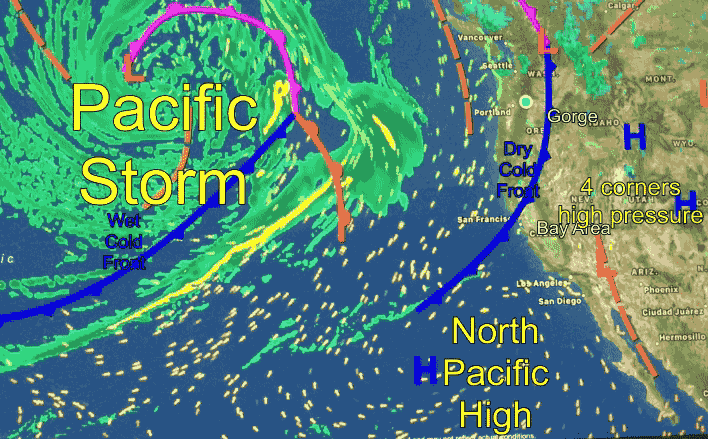
First notice the relative small North Pacific High in the lower right corner of this image of pacific and west coast. Notice that its clockwise winds are creating weak NW winds along the coast of Baja. Back in the summer the NPH was much larger and located west of Northern California.
Now notice the huge pacific storm and its counter-clockwise spinning winds that is slowly plodding towards the Pacific Northwest. The bands of rain in this storm are in green. Also notice the cold front associated with this storm.
Next notice the developing high pressure in the 4 corners area of the USA. This high pressure moved in in the wake of the recent storm and should make for a mild El Norte wind event in Baja’s Sea of Cortez tomorrow and/or Tuesday.
Come spring the average path of the upper trough at ≈ 18,000 ft. will slowly move north and you will see the storm track move northward. And as spring progresses the average position of the North Pacific High will be in California waters and the stage will be set for NW clearing winds.