Maybe you’ve seen satellite images or loops of beautiful moving cloudscapes, ever-changing and flowing through the atmosphere. Sure, the quality of the images makes for amazing time-lapse movies, but do you know how to read what the clouds are telling you? Stay tuned for a quick lesson from a typical Florida July day.
The loop in this blog is from NOAA’s GOES 16 satellite that was launched in 2016 and went operational at the end of 2017, vastly changing the quality of images we are able to see of the Earth from space, mainly because it’s resolution is leaps and bounds ahead of the GOES 16 satellite’s predecessor. A few fun facts about the GOES satellites and then we’ll get to the fun stuff. #TheMoreYouKnow. You can look up your own real-time GOES 16 images by Google searching “GOES 16 imagery viewer” and clicking the first link.
- GOES stands for “Geostationary Operational Environmental Satellite”
- Sends images as often as every 30 seconds to 5 minutes
- Resolution is down to 1-2 kilometers
- First operational lightning mapper in geostationary orbit
Below is a GOES 16 satellite loop over Florida from about 1:30pm to 4pm EDT on 7/20/20, showing the “visible” band. Let’s take a look at several interesting features we can see in just one image.
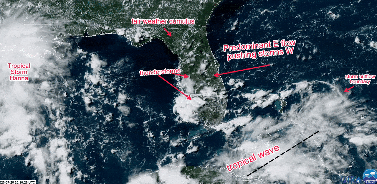
First, notice the pinhead-tiny white dots all over the landmass – these are fair weather cumulus clouds and indicate heating and thermal flow. These often look like puffy cotton balls in the sky.
Next, notice the large white blobs of clouds over southern-central Florida. See how the clouds look like bubbles rising up into the air? That’s a classic sign of thunderstorms. (See my last blog post on the life cycle of a thunderstorm.)
Watching the direction of the clouds gives us an idea of the overall wind flow. It’s easy to see that the predominant wind flow is from the East and that it is pumping all the way across Florida. The thunderstorms and fair weather cumulus are all shifting eastward across the state. This is one of the ways forecasters use to determine where the strongest thunderstorms will occur in the afternoon hours over the Florida peninsula. Strong prevailing easterly flow indicates storms will be pushed towards the Gulf coast side while prevailing westerly flow often means stronger storms will concentrate along the Atlantic coast.
A few more fun things to note inside this loop…
Tropical Storm Hanna was just forming in the central Gulf of Mexico (left side of the frame), while another small tropical wave was over the Bahamas, producing thunderstorms.
One of the best parts about getting satellite images every 5-10 minutes is that you can watch the thunderstorms from conception to dissipation very easily. Take a look at the far right hand side of the screen. See that line of clouds in the curved shape of a bow (like a bow & arrow) fleeing away from the thunderstorms? That is what we call an outflow boundary. Outflow boundaries are caused by rain-cooled air sinking to the surface and accelerating as they spread out and away from the storm- usually in a strong gust.
Now the next time you see cool clouds in a satellite image or movie, you can pick out what the clouds are actually telling you.