By WeatherFlow meteorologist Shea Gibson.
In Part I, we discussed the general understanding of how Sea Breezes work. In part II, we will look at the different classifications of Sea Breezes and how each one works.
In order to fully understand the “Is there only one kind of Sea Breeze?” question – and since they are not all the same, we will need to look at the 4 different current classifications – with 3 of the 4 being the main ones…”Pure Sea Breeze”, “Corkscrew Sea Breeze” and the “Backdoor Sea Breeze”. The “Synoptic Sea Breeze” is a bit different and sometimes limited to weak overall system patterns, so we’ll take that one last. Let’s get started with the first.
Pure Sea Breeze:
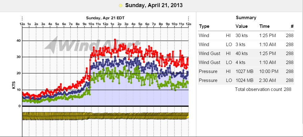
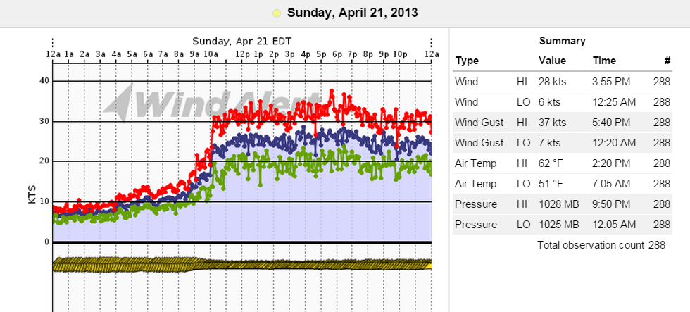
This breeze is very common and occurs without a vast synoptic flow (large scale flow as in a strong Bermuda High for e.g.) …and is usually perpendicular to shore. For GA, it would be a general ESE flow perpendicular to the ESE facing beaches. As we head north into SC, this takes on a more SE direction…. and SSE/SE up into Southeast NC. This breeze relies heavily on air-to-water temperature differential. The smaller the differential, the weaker and later the Sea Breeze may be. By default, even with rains and storms traversing the areas, we can still see a ridge of High pressure build back along the immediate coast to get the light to modest flow going again. At times with a stronger synoptic flow, a warmer air wedge can settle out over the water and act as an artificial shoreline. This would make 2 Sea Breeze fronts where there is calm in between – this happens quite a bit in the spring where marine layering/sea fog hugs into along the beaches and is clear just inland where Sea Breeze front is elevating winds (due to warm air from land streaming downwind)…and also where the Gulf Stream is helping to fuel the offshore breeze from behind. We could even call the Gulf Stream a secondary artificial shoreline in some cases with its much warmer surface temps. The Pure Sea Breeze, overall, can many times limit the builds to modest speeds as moisture streams in from the ocean to contaminate what would be a convergence zone inland. In this case, precipitations would be freely allowed to occur almost anywhere, which would keep any kind of buildup inland very minimal and at times, non-existent. Other times, it can show higher numbers inland just along the front and weaker values behind it as the front penetrates further inland. In most cases for speeds (over years of observations) the limitation along the immediate coast tends to be 9-13kts; however, there are the very infrequent exceptions to the rule if the gradient is tightened over the area to increase speeds…or is influenced by tropical activities lifting from the south. This is very seldom as the Pure Sea Breezes generally bring lighter overall flows.
We can clearly see this type of breeze when subtropical ridging takes effect where High pressure in the Atlantic flattens and places a ridge axis along the coast to provide a weaker overall pattern. See this article for details and meaning of subtropical ridging: https://blog.weatherflow.com/subtropical-ridging-effects-in-the-se-region/
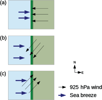
Picture below represents flows of winds. Pure Sea Breezes are shown in figure (a). Green shading represents land where straight offshore Land Breezes (3 black arrows) are eventually undercut by straight onshore Sea Breezes ( 2 blue arrows).
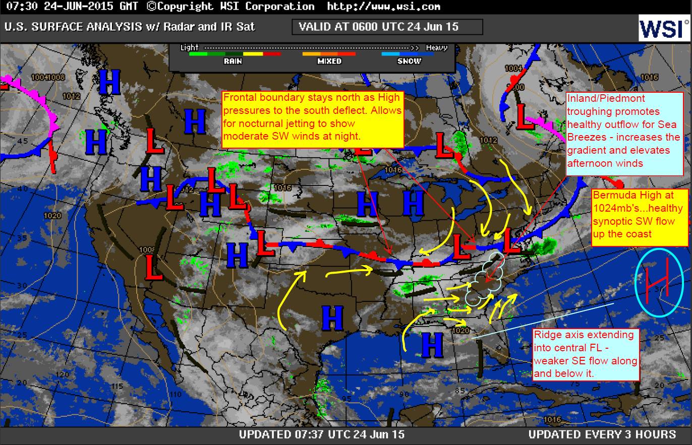
Here is an example of a weather pattern that presents the ridging effect which prompts Pure Sea Breezes – this one showing the bulk of effects to the FL/GA/SC coastline where winds are weakest near the axis as High pressure is squeezed and flattened in between two frontal boundaries:
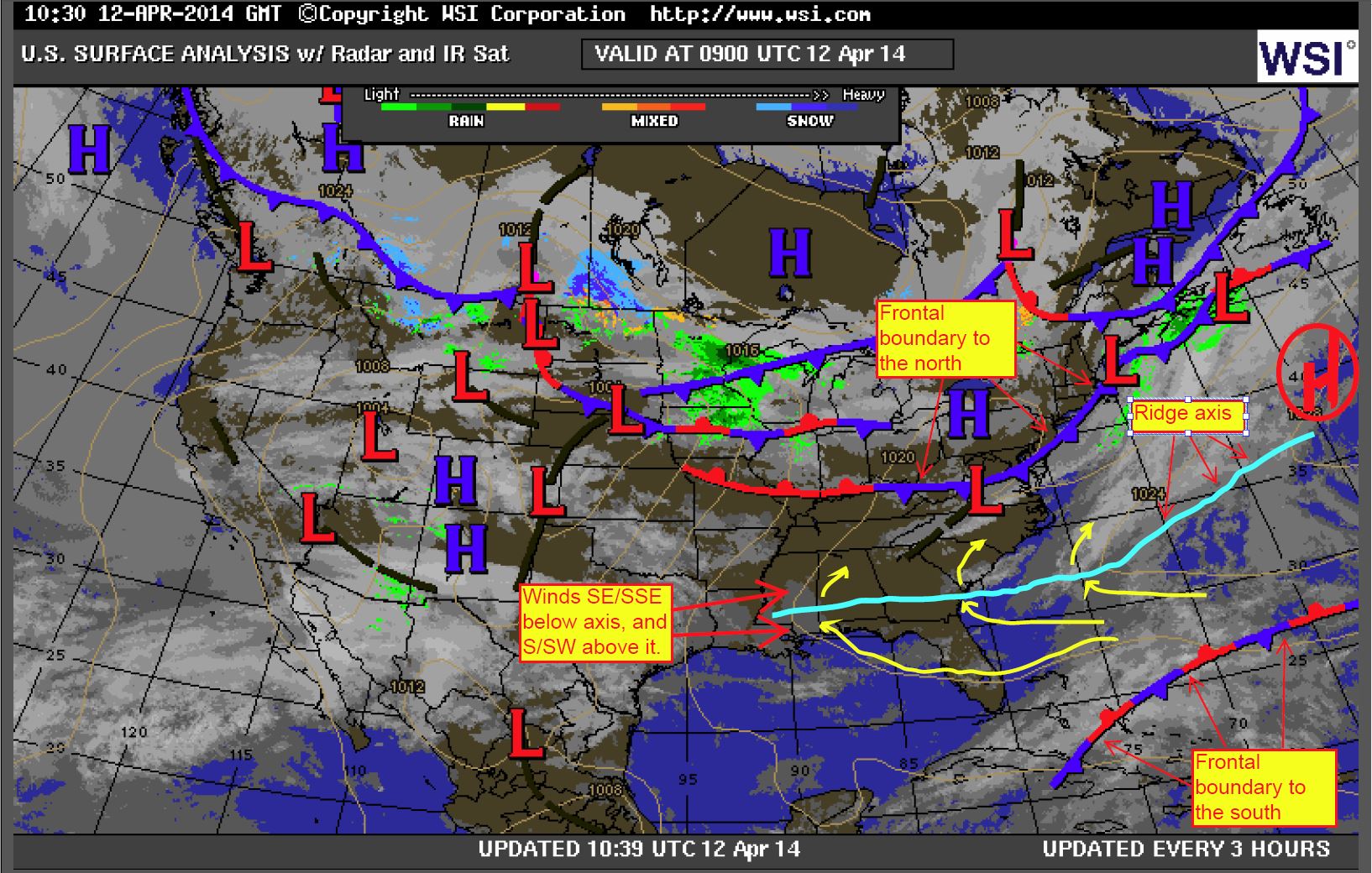
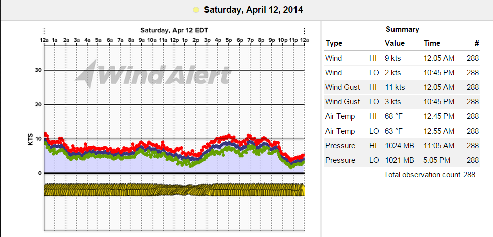
And an example of what occurs with this weakening pattern at Oak Island, NC where the South direction is directly perpendicular to the coastline in that section of Southeast NC.
Corkscrew Sea Breeze:
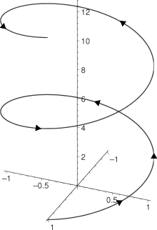
The Corkscrew Sea Breeze is the most common of the Sea Breezes along the SE Region – especially during the warmer months. This breeze can start out with an offshore Land Breeze that eventually turns onshore as the Sea Breeze pushes ashore and heads inland, giving it a helix shape. Sometimes the land breeze can become so aggressive that the Sea Breeze struggles to undercut the land breeze, where this corkscrewing effect creates a very shifty and punchy quality in the wind along the beaches until one wins out the flow (Sea Breeze usually does unless surface High offshore is weaker). With land to the left of water in the Northern Hemisphere, surface divergence (surface Bermuda High pressure for example) encountering land friction allows the Sea Breeze to gain momentum and creates this helix, or corkscrewing effect. Once the Sea Breeze has set in along the coast, it builds and in many cases begins to veer (or tilts) due to the Coriolis effect. For the SE Region, this is usually around 5 degrees of backing per hour. The bend goes until the wind is 45 degrees to shore (somewhat parallel) and remains fixed until fading in to the evening. So that would explain SC winds backing from S or SSW over to SW – especially just inside of coastal breaks, harbors and sounds where heated land masses fuel the hotter air. This type of breeze also is a powerful generator of convergence zones inland as the gradient tightens behind the Sea Breeze front and thermals increase vertical stacking of clouds. The result is stronger convection and/or thunderstorm lines along the head of the front. Outflow becomes optimal as the offshore winds aloft help to send air back out over the ocean (called “return flow”) where it cools, condenses and circulates back into the Sea Breeze. This goes faster and faster depending on offshore upper air movement working in unison with the onshore air movement below.
Here is an example of a helix with a healthy Corkscrew Sea Breeze circulation. Immediate coast is typically dry and void of clouds overhead during this setup – at least until storms develop along the convergence zone. Then the SB Front can either hold the storming inland or sometimes it is just too powerful and overruns the coast and forces the Sea Breeze front (where clouds are building) to retreat quickly back offshore.
Picture below represents flows of winds. Corkscrew Sea Breezes are shown in figure (b). Green shading represents land where angled offshore Land Breezes (3 black arrows) are eventually undercut by straight onshore Sea Breezes (2 blue arrows).
Here is a good example of the Westerly flow over the SE Region prompted by moderate northeast Gulf of Mexico High pressure. Sometimes this NE GOM High can become stronger and make the land breezes more aggressive. The Bermuda High is providing a Southerly flow to encounter it at the coast, where the “helix” or corkscrew occurs. With inland troughing/thunderstorm activity, this breeze builds to moderate and strong levels – typically stronger further up the coast.
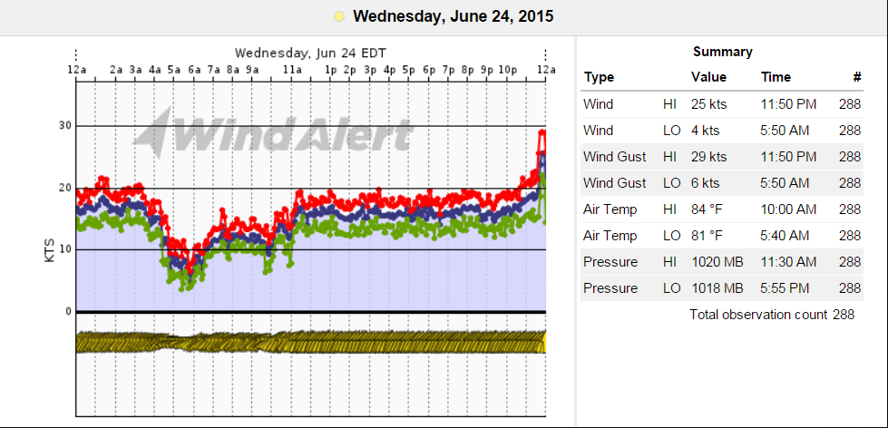
Here are the results from 6/24/15 at Isle of Palms, SC. You can see the morning WSW’erlies fade and the SSW’rlies build and hold throughout the day.
Backdoor Sea Breeze:
This breeze is one of the hardest to forecast speeds for – and one of the most fascinating (at least to me) to watch the real-time observations as it can show an explosion of strong winds. It’s relatively easy to see coming, but the wind strength it generates and the timing of arrival catches us off-guard many times each year – and it certainly does catch beachgoers/boaters off-guard. Computer models do fairly well on directions, but very little for guidance on speeds as they do not always catch the microclimate thermodynamics of what occurs along our immediate coast. These are stronger when the waters are warming up in the spring and we still see cold weather trying to make its way down from the north as the Polar Jet recedes. Adversely, we see this in the fall and during winter when the Polar Jet is advancing south to wedge these colder air masses into the Southeast Region.
Backdoor Sea Breezes are generally associated with cold front/backdoor cold front passages and cooler NE winds pressing down from High pressures to the north wedging down behind them (Canadian/Great Lakes/NE High’s). The stronger the High, the stronger the gradient and ultimately, the stronger the winds. For examples…1024 millibars is moderate…1032-1040mb’s brings strong winds and when we start to see 1042-1051 High pressures, we can reach gale force speeds. Residual coastal troughing or offshore low pressure(s) from these dissipating fronts interacting with this strong surface sinking of air with a healthy clockwise flow tightens the gradient as winds speed up between the two systems. In other words, and by the Buys-Ballot law, the gradient tightens and a convergence zone is created at the coast (instead of inland). The result is cooler air “advecting” (in many cases this air is slanting down at an angle into shore, or wedging) down over the warmer waters, which creates an additional unique temperature gradient where air is forced into the hotter land. The warmer land acts as an accelerator and winds are specifically stronger just along the land-and-sea interface – many cases the stronger flow is restricted to beaches. The barrier islands and lee-side marshlands usually feel the brunt of these accelerations as winds start to fade while heading inland as the air lifts. You can sometimes catch a visual when associated clouding in the area has a single sided wedge shape -and you could almost think of this as winds swooping down to the surface and scooping back up (a dip in the winds). Storms can be triggered along the coast with heavier troughing and weaker High pressure, but this is not a typical Sea Breeze and does not require circulations. This is an “oscillation” where the winds are generated onshore only without a return flow overhead. In other words…this is more of a forced wind into the coast.
Picture below represents flows of winds. Backdoor Sea Breezes are shown in figure (c). Green shading represents land where angled onshore breezes (3 black arrows) are eventually accelerated by Sea Breezes (2 blue arrows) – or the cold air advection process.
It is very common for winds to linger as offshore Northerly values before land heating starts to bend the wind field from Coriolis effects as the sun rises further in the sky. As winds “peek” around the corner and become side-shore, they accelerate quickly as the warmer water now becomes its fuel. As winds lean more onshore at a 45 – 75 degrees for SC/GA, the jumpiness usually settles into a more consistent flow. NC has leans according to their land masses, but many locales with southerly facing beaches remain offshore and weaker for these events. The outer capes and E/SE facing beaches feel the acceleration effects. It is not known if there is a 5 degree shift per hour as in the Corkscrew Sea Breezes (could be a good theory to investigate), but we do know that these winds generally will lean perpendicular to shore later in the day as air temps/land temps cool. For the Southeast, this would be an Easterly wind, which becomes more ocean saturated and weaker in nature – especially later in the day as heating dissipates. Specifically, Charleston SC is known for its extreme increases in speeds…and I firmly believe that this is largely due to the 3 river system allowing for earlier advection of the offshore Northerlies to gain momentum. There is also a large open body of water that curves well inland to the north of Charleston (Bulls Bay) to allow for the side-shore increased momentum and the urban heat island effects to help make that Sea Breeze shift to from NNE/NE–>ENE all the more inviting.
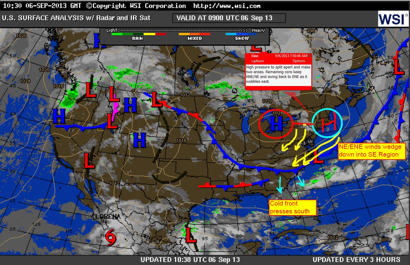
Typical surface map of what this might look like as NE/ENE winds wedge down behind backdoor fronts. This one from September 6, 2013.
Here is an example of how fast the Backdoor Sea Breeze can come up in Charleston, SC along the immediate beaches. Some of this has to do with station placement reading weaker with land shadowing from offshore values earlier; however, if we look at the Charleston Harbor, we can see the elevations came up at the same time, which further proves this is a rapid acceleration process. This particular event caused the cancellation of the Charleston Race Week finals as the officials were well tuned in to the human forecast for the area versus the model forecast.
Isle of Palms Pier – highest gust during peak heating – notice the jump just before 10AM -that’s a 10-15kt jump in speeds all at once!
Charleston Harbor (Front Range Light centered near the middle of the inner harbor mouth)
Here’s classic example of the NE–>ENE–>E flow fading as winds lean more and more East over time during the cooling process.
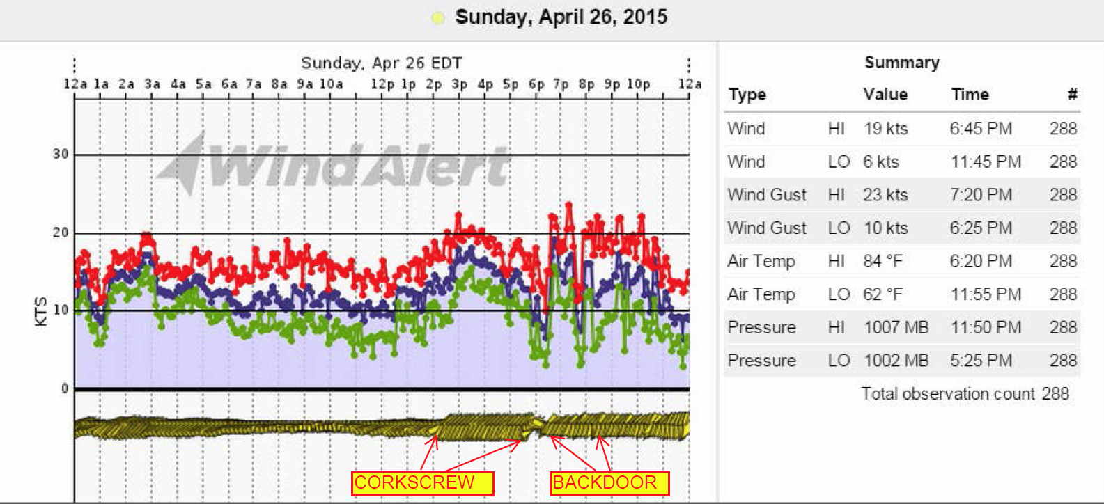
And lastly here is a wild day on April 26, 2015 at Isle of Palms/Sullivan’s Island, SC where we saw an elevated Corkscrew Sea Breezes shift to a Backdoor Sea Breeze as a backdoor cold front crept down the coast from the north. Visual observation was angular clouding.
Synoptic Sea Breeze or “Default Sea Breeze”:
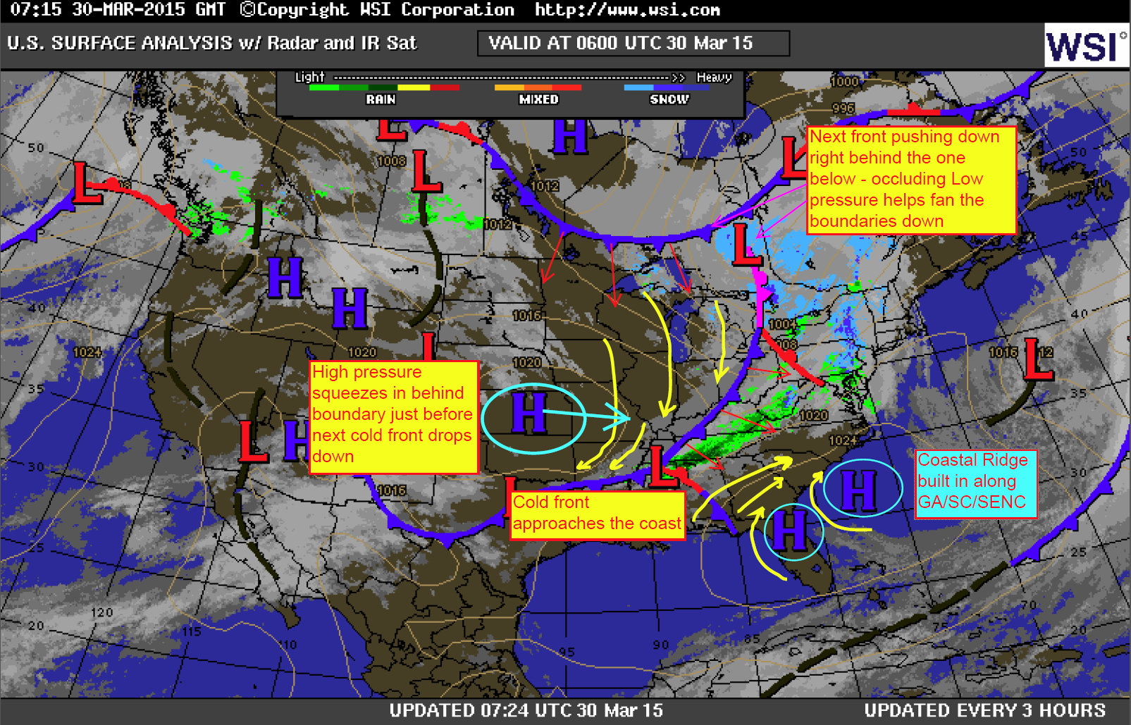
This one applies to when there is a weak overall pattern in place and we see a High pressure ridge develop along the coast by default. This usually starts from the south and spreads to the north up the immediate coastline. This type of Sea Breeze oscillates into the coast with a very mild or modest onshore temperature gradient only. A classic example of this we can see in the winter time when Northerly and Westerly winds diminish to at or below somewhere under 5 – 6kts. Ever wonder how those S/SW’rlies appear out of nowhere? With cooler waters and somewhat warmer land, we systematically see winds switch up from the S/SSW/SW and remain light to modest at best. Since there is no inland convergence or thunderstorming available within the abundantly cooler overall air, this breeze simply flows on the one leg of a pseudo Corkscrew Sea Breeze – or the temperature gradient to be more specific. You could say this type of breeze could be a hybrid type of Pure Sea Breeze with corkscrew-like characteristics. We also see this more pronounced during the spring when fronts decay overhead, warm fronts lift or when marine layering hampers development over the cooler, more stable shelf waters. High pressure tends to develop along southern SC/mid to northern GA in the curve or “coastal pocket” where heat fluxing creates this surface High pressure ridge that expands up the coast to SC and SENC (very similar to the Northeast Gulf of Mexico High). We could in theory call this the “Carolina Coastal Ridge Breeze” per our coastal sensor observations and mesoscale analysis showing winds barbs pointing up the coast. It also can receive a little help from warmer Gulf Stream waters to the east as it eddies in closer to the coast at times…or simply acts as an artificial land mass with its warmer surface temps. This would provide an offshore gradient able to make it onshore at times as it meanders in and out of the coast.
This is a very tricky one to catch as it tends to be so subtle, the coastal High pressure ridge many times does not even appear on surface maps. So it’s kind of a “default ridge” that develops without notice. It’s almost as if the air refuses to remain still along the land and sea interface – and it is very rare to see completely calm winds (usually only in heavy fogging or short-lived periods of 100% stability).
Here’s one instance where we can see the coastal ridge on a larger scale (this one was actually picked up by surface maps) assisted by an eastward meandering northeast Gulf High. A frontal boundary had recently fizzled along the coast associated with the Low pressure to the northeast.
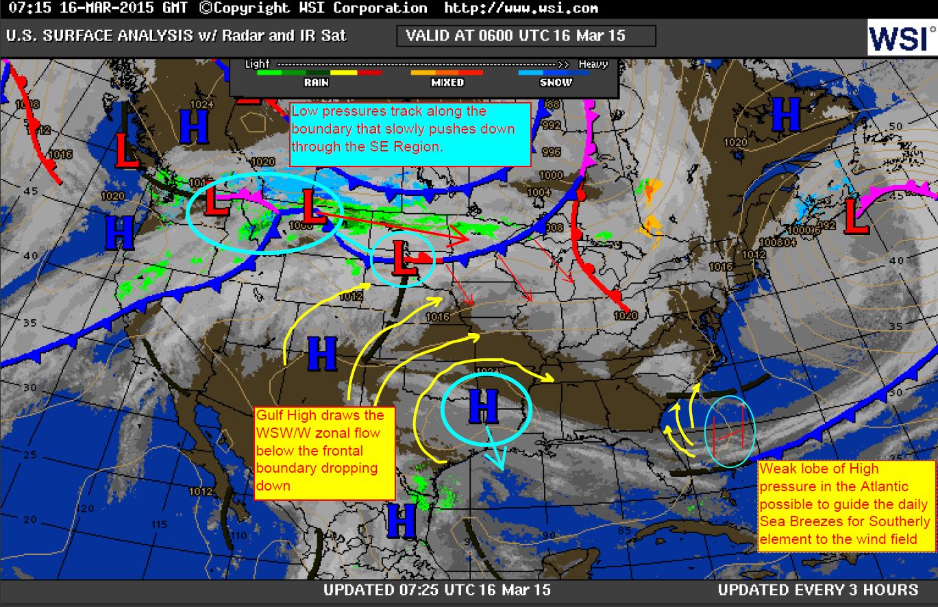
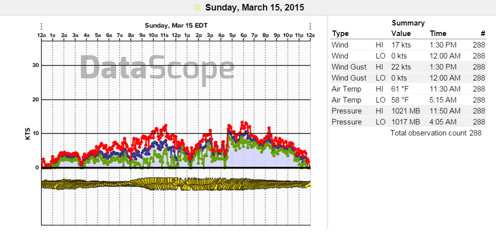
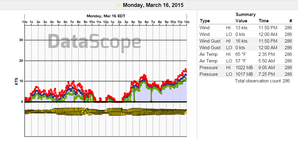
And here are the two days of March 15th and 16th, 2015, where the coastal ridge set up light to somewhat modest Southerly winds as Northerly winds weakened below 5-6kts (I was able to catch and sketch it in on the surface map for March 16).
Results for the beaches – this one from Isle of Palms, SC. You can see the shift from Northerly to SW’rly each day.
The last type of Sea Breeze mentioned here, the Synoptic Sea Breeze or as we could name it…the “Default” or “Carolina Coastal Ridge Breeze” is definitely up for discussion as it seems to be very elusive in studies. This particular classification will require more observations from our WeatherFlow mesonet and further discussion amongst our meteorologist team and partners. The 3 main types of Sea Breezes (Pure, Corkscrew and Backdoor) have been classified from intensive studies and profiling, which helps to better understand how Sea Breezes work along our coastline.
Stay tuned for the next part in this series where we will look at “What would the Sea Breeze look like?” I will present the anatomy of what the Sea Breeze front and its components would look like if viewing from the side – and how each part of the front works.
Cheers!
Shea Gibson
WeatherFlow Forecast Team, SE Region