
If Matt and my forecasts are right we are in for a long spell of moderate El Norte winds coming down Sea of Cortez from the Great Basin. The 3 part blog looks at the 3 major causes of this event from Nov. 20 to around Nov. 25.
Typically El Norte wind events last 2-3 days as high pressure moves into the Great Basin and then is bumped eastward by an inbound storm. So Baja’s East Cape sees 2-3 days of upper-teens to low 20’s or stronger northerly wind that then fades away. Why is this event forecast to last 5 or more days?
- At the surface, high pressure lingers for 5 days in the Great Basin between California’s Sierra Nevada and the Rocky mountains. Part 1 of this blog covers this factor.
- Up at the jetstream an upper ridge forms that locks that surface high pressure in place and blocks inbound storms that could move the high pressure. Meanwhile, convergence from the high pressure enhances the surface high pressure. Part 2 of this blog covers this factor.
- Since the El Norte winds are roughly parallel to the rugged Sea of Cortez coast of Baja terrain friction keeps the winds weaker near shore. So we need blue skies for coastal valleys heating to create a local pressure gradient to suck the El Norte wind to the beach and to also increase its strength. Part 3 of this blog covers this factor.
Part 1: Lingering surface high-pressure anchors in the Great Basin for about 5 days.
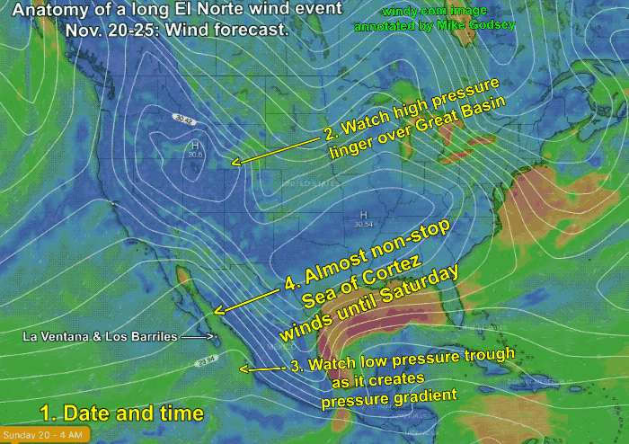
Watching this animation note the date at the bottom. from Sunday, November 20 to Saturday, November 26.
The animation shows the high pressure over the Great Basin and the low-pressure trough south of Cabo that keep the the El Norte winds blowing day after day. Notice how the high pressure wobbles about and changes shape but it constantly keeps white isobar lines over the Sea of Cortez. Those isobar lines represent the pressure gradient towards the inverted low-pressure trough south of Cabo San Lucas The green color represents strong wind.